Geolocate

New Hope topographic map

Click on the map to display elevation.

About this map

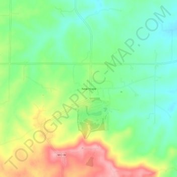
Name: New Hope topographic map, elevation, terrain.

Location: New Hope, Lincoln County, Missouri, United States (39.11671 -90.88430 39.15671 -90.84430)

Average elevation: 728 ft

Minimum elevation: 568 ft

Maximum elevation: 981 ft

Lincoln County trails, hiking, mountain biking, running and outdoor activities

Other topographic maps

Click on a map to view its topography, its elevation and its terrain.

Winfield

United States > Missouri > Lincoln County

Average elevation: 469 ft

Truxton

United States > Missouri > Lincoln County

Average elevation: 709 ft

Troy

United States > Missouri > Lincoln County

Average elevation: 564 ft

Moscow Mills

United States > Missouri > Lincoln County

Average elevation: 502 ft

Silex

United States > Missouri > Lincoln County

Average elevation: 568 ft

Elsberry

United States > Missouri > Lincoln County

Average elevation: 466 ft

Gear up for your next adventure:

🧴Hand Sanitizer - Keep hands clean while hiking
🚁Photography Drones - Capture stunning aerial views of landforms and topography
🌡️Portable Weather Meter - Track weather conditions on the trail
🪶Paracord Bracelet - Survival bracelet with built‑in tools
🧺Microfiber Travel Towels - Compact and fast-drying towels for trail use

As an Amazon Associate, this site earns from qualifying purchases at no extra cost to you.