Geolocate

Malo topographic map

Click on the map to display elevation.

About this map

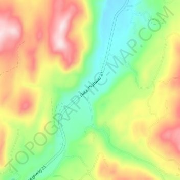
Name: Malo topographic map, elevation, terrain.

Location: Malo, Ferry County, Washington, 99160, United States (48.78156 -118.62697 48.82156 -118.58697)

Average elevation: 2,585 ft

Minimum elevation: 2,047 ft

Maximum elevation: 3,274 ft

Ferry County trails, hiking, mountain biking, running and outdoor activities

Other topographic maps

Click on a map to view its topography, its elevation and its terrain.

Inchelium

United States > Washington > Ferry County

Average elevation: 2,096 ft

Keller

United States > Washington > Ferry County > Keller

Average elevation: 2,218 ft

Ferry Lake

United States > Washington > Ferry County

Average elevation: 3,432 ft

Wiseman Island

United States > Washington > Ferry County > Pollard

Average elevation: 2,549 ft

Gear up for your next adventure:

🌐World Map Poster - Decorative world maps with topographic info
🧭Pro Hiking Compasses - High-accuracy liquid-filled compasses for topographic orientation
🧭Outdoor Navigation Book - Learn advanced navigation skills
🖼️Topo Map Wall Art - Decorative topographic prints of famous peaks and regions
🍳Camping Cook Set - Complete cookware for outdoor meals

As an Amazon Associate, this site earns from qualifying purchases at no extra cost to you.