Geolocate

Marsh Crossing topographic map

Click on the map to display elevation.

About this map

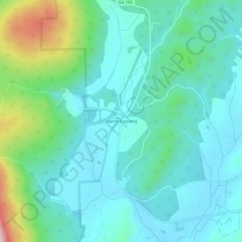
Name: Marsh Crossing topographic map, elevation, terrain.

Location: Marsh Crossing, Walker County, Georgia, United States (34.69730 -85.34829 34.73730 -85.30829)

Average elevation: 1,024 ft

Minimum elevation: 764 ft

Maximum elevation: 2,001 ft

Walker County trails, hiking, mountain biking, running and outdoor activities

Other topographic maps

Click on a map to view its topography, its elevation and its terrain.

Lookout Mountain

United States > Georgia > Walker County

Average elevation: 1,332 ft

Chattanooga Valley

United States > Georgia > Walker County

Average elevation: 906 ft

Rock Spring

United States > Georgia > Walker County

Average elevation: 863 ft

Fairview

United States > Georgia > Walker County

Average elevation: 863 ft

Missionary Ridge

United States > Georgia > Walker County

Average elevation: 1,106 ft

Gear up for your next adventure:

🛰️Satellite Messengers - Emergency SOS and two-way messaging for off-grid adventures
🔭Compact Binoculars - HD vision for scouting terrain and identifying distant landmarks
🪶Trail Camera - Capture wildlife on your hikes
📶Satellite Messenger - Communication device off‑grid
📻Weather Alert Radios - Stay informed of storm risks while off-the-grid

As an Amazon Associate, this site earns from qualifying purchases at no extra cost to you.