Geolocate

Lakeside topographic map

Click on the map to display elevation.

About this map

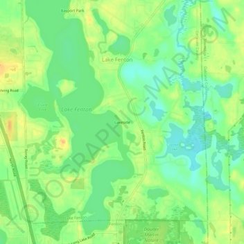
Name: Lakeside topographic map, elevation, terrain.

Location: Lakeside, Genesee County, Michigan, United States (42.81586 -83.72662 42.85586 -83.68662)

Average elevation: 879 ft

Minimum elevation: 833 ft

Maximum elevation: 928 ft

Genesee County trails, hiking, mountain biking, running and outdoor activities

Other topographic maps

Click on a map to view its topography, its elevation and its terrain.

Linden

United States > Michigan > Genesee County

Average elevation: 889 ft

Lake Fenton

United States > Michigan > Genesee County

Average elevation: 883 ft

Goodrich

United States > Michigan > Genesee County

Average elevation: 889 ft

Atlas County Park

United States > Michigan > Genesee County > Atlas

Average elevation: 873 ft

Beecher

United States > Michigan > Genesee County

Average elevation: 778 ft

Mount Morris

United States > Michigan > Genesee County

Average elevation: 778 ft

Gaines

United States > Michigan > Genesee County

Average elevation: 846 ft

Lennon

United States > Michigan > Genesee County

Average elevation: 771 ft

Otisville

United States > Michigan > Genesee County

Average elevation: 814 ft

Otter Lake

United States > Michigan > Genesee County

Average elevation: 863 ft

Seely Lake

United States > Michigan > Genesee County

Average elevation: 863 ft

Montrose

United States > Michigan > Genesee County

Average elevation: 666 ft

Gear up for your next adventure:

🏫Relief Map Kits - Hands-on tools for teaching landforms and elevation
🛠️Outdoor Gear Repair Kit - Essential tools to fix gear on the trail
🧤Hiking Gloves - Protective gloves for rugged trails
📚USA Hiking Guide Books - Top trail guides and map books
🪑Portable Camp Table - Compact table for campsite meals

As an Amazon Associate, this site earns from qualifying purchases at no extra cost to you.