Geolocate

Jackson topographic map

Click on the map to display elevation.

About this map

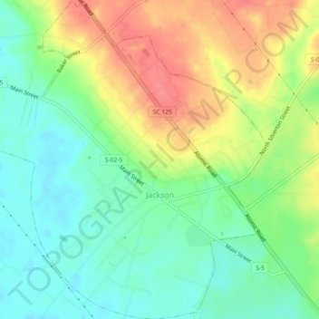
Name: Jackson topographic map, elevation, terrain.

Location: Jackson, Aiken County, South Carolina, United States (33.31073 -81.81609 33.34818 -81.77281)

Average elevation: 236 ft

Minimum elevation: 148 ft

Maximum elevation: 358 ft

Aiken County trails, hiking, mountain biking, running and outdoor activities

Other topographic maps

Click on a map to view its topography, its elevation and its terrain.

Langley

United States > South Carolina > Aiken County > Burnettown

Average elevation: 269 ft

Couchton

United States > South Carolina > Aiken County

Average elevation: 413 ft

Aiken

United States > South Carolina > Aiken County > Aiken > Aiken

Average elevation: 469 ft

Hunters Glen

United States > South Carolina > Aiken County > Aiken

Average elevation: 446 ft

Gear up for your next adventure:

🧢Outdoor Hiking Hat - Sun protection hat for outdoor explorers
🏕️Family Camping Gear - Essentials for group camping trips
🚪Portable Camp Chair - Foldable chair for comfort at camp
❄️Traction Cleats - Prevent slips on icy trails during winter hikes
🥩Freeze-Dried Meals - Nutritious and lightweight food for remote expeditions

As an Amazon Associate, this site earns from qualifying purchases at no extra cost to you.