
Make a donation
Gear up for your next adventure:
As an Amazon Associate, this site earns from qualifying purchases at no extra cost to you.
Baneh County topographic map
Click on the map to display elevation.
Make a donation
Gear up for your next adventure:
As an Amazon Associate, this site earns from qualifying purchases at no extra cost to you.
About this map
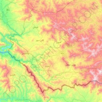
Name: Baneh County topographic map, elevation, terrain.
Location: Baneh County, Kurdistan Province, Iran (35.79901 45.55765 36.20820 46.17826)
Average elevation: 5,331 ft
Minimum elevation: 2,523 ft
Maximum elevation: 9,127 ft
Make a donation
Gear up for your next adventure:
As an Amazon Associate, this site earns from qualifying purchases at no extra cost to you.
Other topographic maps
Click on a map to view its topography, its elevation and its terrain.
Make a donation
Gear up for your next adventure:
As an Amazon Associate, this site earns from qualifying purchases at no extra cost to you.
Gazan-e Bala
Iran > Kurdistan Province > Sanandaj County > دهستان حسین آبادجنوبی
Average elevation: 6,332 ft
Bani Dar
Iran > Kurdistan Province > Sanandaj County > دهستان نگل > Bani Dar
Average elevation: 5,433 ft
Make a donation
Gear up for your next adventure:
As an Amazon Associate, this site earns from qualifying purchases at no extra cost to you.
Avihang
Iran > Kurdistan Province > Sanandaj County > دهستان ژاورود غربی > Avihang
Average elevation: 6,171 ft
Tazehabad-e Sarab-e Qaht
Iran > Kurdistan Province > Ghorveh County > Tazehabad-e Sarab-e Qaht
Average elevation: 6,158 ft
Make a donation
Gear up for your next adventure:
As an Amazon Associate, this site earns from qualifying purchases at no extra cost to you.