
Make a donation
Gear up for your next adventure:
As an Amazon Associate, this site earns from qualifying purchases at no extra cost to you.
Hadrut Province topographic map
Click on the map to display elevation.
Make a donation
Gear up for your next adventure:
As an Amazon Associate, this site earns from qualifying purchases at no extra cost to you.
Hadrut Province
Hadrut Province formed the breakaway Republic of Artsakh's southern border and is one of its most mountainous parts. Villages were primarily found along two river valleys and scattered in lower elevations on the very southern fringe. Excavations of the Azokh Cave showed that humans have inhabited this area for tens of thousands of years, and the region has a rich history.
Make a donation
Gear up for your next adventure:
As an Amazon Associate, this site earns from qualifying purchases at no extra cost to you.
About this map
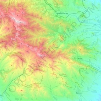
Name: Hadrut Province topographic map, elevation, terrain.
Location: Hadrut Province, Khojavend District, Karabakh, Azerbaijan (39.41255 46.65376 39.67758 47.11746)
Average elevation: 3,658 ft
Minimum elevation: 1,112 ft
Maximum elevation: 8,802 ft
Make a donation
Gear up for your next adventure:
As an Amazon Associate, this site earns from qualifying purchases at no extra cost to you.
Other topographic maps
Click on a map to view its topography, its elevation and its terrain.
Make a donation
Gear up for your next adventure:
As an Amazon Associate, this site earns from qualifying purchases at no extra cost to you.