Geolocate

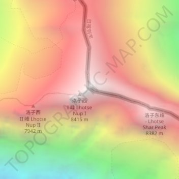
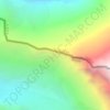
Lhotse topographic map

Click on the map to display elevation.

Lhotse

Lhotse (Nepali: ल्होत्से, romanized: L'hōtsē [lotse]; Standard Tibetan: ལྷོ་རྩེ, romanized: lho tse, lit. 'South Peak' [l̥otse]; Chinese: 洛子峰) is the fourth-highest mountain on Earth, after Mount Everest, K2, and Kangchenjunga. At an elevation of 8,516 metres (27,940 ft) above sea level, the main summit is on the border between the Tibet Autonomous Region of China and the Khumbu region of Nepal.

Wikipedia (CC-BY-SA 3.0)

About this map

Name: Lhotse topographic map, elevation, terrain.

Location: Lhotse, Khumbupasanglahmu, Solukhumbu, Koshi Province, Nepal (27.96194 86.93245 27.96204 86.93255)

Average elevation: 24,249 ft

Minimum elevation: 18,963 ft

Maximum elevation: 27,884 ft

Other topographic maps

Click on a map to view its topography, its elevation and its terrain.

Khumbupasanglahmu

Nepal > Koshi Province > Solukhumbu

Average elevation: 16,106 ft

Sotang

Nepal > Koshi Province > Solukhumbu

Average elevation: 7,129 ft

Likhupike

Nepal > Koshi Province > Solukhumbu

Average elevation: 9,039 ft

West Ridge

Nepal > Koshi Province > Solukhumbu

Average elevation: 23,081 ft

Khumbupasanglahmu-05

Nepal > Koshi Province > Solukhumbu

Average elevation: 17,165 ft

Gear up for your next adventure:

📷Action Cameras - Rugged cameras to document your journeys across rugged terrain
🌐World Map Poster - Decorative world maps with topographic info
🔌USB Car Charger - Car charger for on‑the‑go power needs
🚑Emergency Bivvies - Heat-reflective sleeping bags for survival situations
🧭Pro Hiking Compasses - High-accuracy liquid-filled compasses for topographic orientation

As an Amazon Associate, this site earns from qualifying purchases at no extra cost to you.