
Make a donation
Gear up for your next adventure:
As an Amazon Associate, this site earns from qualifying purchases at no extra cost to you.
Praia Grande topographic map
Click on the map to display elevation.
Make a donation
Gear up for your next adventure:
As an Amazon Associate, this site earns from qualifying purchases at no extra cost to you.
About this map
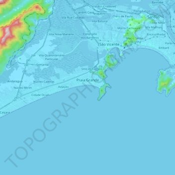
Name: Praia Grande topographic map, elevation, terrain.
Average elevation: 75 ft
Minimum elevation: -7 ft
Maximum elevation: 2,510 ft
Make a donation
Gear up for your next adventure:
As an Amazon Associate, this site earns from qualifying purchases at no extra cost to you.
Other topographic maps
Click on a map to view its topography, its elevation and its terrain.
Centro
Brasil > São Paulo > Região Metropolitana da Baixada Santista > Santos
Average elevation: 46 ft
Rio Cubatão
Brasil > São Paulo > Região Metropolitana da Baixada Santista > Cubatão
Average elevation: 30 ft
Rio Itaguaré
Brasil > São Paulo > Região Metropolitana da Baixada Santista > Bertioga
Average elevation: 10 ft
Praça da santa
Brasil > São Paulo > Região Metropolitana da Baixada Santista > Santos
Average elevation: 115 ft
Make a donation
Gear up for your next adventure:
As an Amazon Associate, this site earns from qualifying purchases at no extra cost to you.
Praia de Pernambuco
Brasil > São Paulo > Região Metropolitana da Baixada Santista > Guarujá
Average elevation: 30 ft
Ilhote Praia Grande
Brasil > São Paulo > Região Metropolitana da Baixada Santista > Guarujá
Average elevation: 174 ft
Ilha Porchat
Brasil > São Paulo > Região Metropolitana da Baixada Santista > São Vicente
Average elevation: 863 ft
Morro de São Lourenço
Brasil > São Paulo > Região Metropolitana da Baixada Santista > Bertioga
Average elevation: 10 ft
Make a donation
Gear up for your next adventure:
As an Amazon Associate, this site earns from qualifying purchases at no extra cost to you.
Praça Doutor Caio Ribeiro de Moraes e Silva
Brasil > São Paulo > Região Metropolitana da Baixada Santista > Santos
Average elevation: 20 ft
Estuário de Santos
Brasil > São Paulo > Região Metropolitana da Baixada Santista > Santos
Average elevation: 33 ft
Morro Santa Terezinha
Brasil > São Paulo > Região Metropolitana da Baixada Santista > Santos
Average elevation: 154 ft
Morro da Penha
Brasil > São Paulo > Região Metropolitana da Baixada Santista > Santos
Average elevation: 118 ft
Make a donation
Gear up for your next adventure:
As an Amazon Associate, this site earns from qualifying purchases at no extra cost to you.
Morro Fontana
Brasil > São Paulo > Região Metropolitana da Baixada Santista > Santos
Average elevation: 164 ft
Serra do Quilombo
Brasil > São Paulo > Região Metropolitana da Baixada Santista > Santos
Average elevation: 883 ft
Rio Preto
Brasil > São Paulo > Região Metropolitana da Baixada Santista > Itanhaém
Average elevation: 79 ft
Praia do Saco do Major
Brasil > São Paulo > Região Metropolitana da Baixada Santista > Guarujá
Average elevation: 148 ft
Make a donation
Gear up for your next adventure:
As an Amazon Associate, this site earns from qualifying purchases at no extra cost to you.
Praça Pindorama
Brasil > São Paulo > Região Metropolitana da Baixada Santista > São Vicente
Average elevation: 16 ft
Morro do Botelho
Brasil > São Paulo > Região Metropolitana da Baixada Santista > Guarujá
Average elevation: 95 ft
Rio Diana
Brasil > São Paulo > Região Metropolitana da Baixada Santista > Santos
Average elevation: 7 ft
Pinheiro
Brasil > São Paulo > Região Metropolitana da Baixada Santista > Itanhaém
Average elevation: 13 ft
Make a donation
Gear up for your next adventure:
As an Amazon Associate, this site earns from qualifying purchases at no extra cost to you.
Morro do Ilhéu Alto
Brasil > São Paulo > Região Metropolitana da Baixada Santista > Santos
Average elevation: 16 ft
Praia Branca
Brasil > São Paulo > Região Metropolitana da Baixada Santista > Guarujá
Average elevation: 108 ft
Morro do Embaré
Brasil > São Paulo > Região Metropolitana da Baixada Santista > São Vicente
Average elevation: 161 ft
Morro do Pinto
Brasil > São Paulo > Região Metropolitana da Baixada Santista > Guarujá
Average elevation: 69 ft
Make a donation
Gear up for your next adventure:
As an Amazon Associate, this site earns from qualifying purchases at no extra cost to you.
Pedra Selada
Brasil > São Paulo > Região Metropolitana da Baixada Santista > Bertioga
Average elevation: 16 ft
Rio Itanhaém
Brasil > São Paulo > Região Metropolitana da Baixada Santista > Itanhaém
Average elevation: 577 ft
Vila Anhanguera
Brasil > São Paulo > Região Metropolitana da Baixada Santista > Mongaguá > Vila Anhanguera
Average elevation: 23 ft
Rio Mariana
Brasil > São Paulo > Região Metropolitana da Baixada Santista > São Vicente
Average elevation: 10 ft
Make a donation
Gear up for your next adventure:
As an Amazon Associate, this site earns from qualifying purchases at no extra cost to you.
Rio Branco
Brasil > São Paulo > Região Metropolitana da Baixada Santista > São Vicente
Average elevation: 1,365 ft