
Make a donation
Gear up for your next adventure:
As an Amazon Associate, this site earns from qualifying purchases at no extra cost to you.
Cubjac topographic map
Click on the map to display elevation.
Make a donation
Gear up for your next adventure:
As an Amazon Associate, this site earns from qualifying purchases at no extra cost to you.
Cubjac
L'altitude minimale, 107 mètres, se trouve au sud-ouest, là où l'Auvézère quitte la commune et entre sur celle du Change. L'altitude maximale avec 253 mètres est localisée au sud-est, au niveau d'un château d'eau, en limite de Montagnac-d'Auberoche.
Make a donation
Gear up for your next adventure:
As an Amazon Associate, this site earns from qualifying purchases at no extra cost to you.
About this map
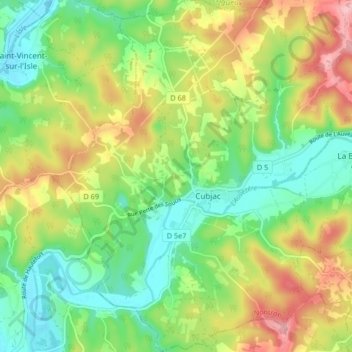
Name: Cubjac topographic map, elevation, terrain.
Average elevation: 545 ft
Minimum elevation: 341 ft
Maximum elevation: 850 ft
Make a donation
Gear up for your next adventure:
As an Amazon Associate, this site earns from qualifying purchases at no extra cost to you.
Other topographic maps
Click on a map to view its topography, its elevation and its terrain.
Nauvialle
France > Nouvelle-Aquitaine > Dordogne > Cubjac-Auvézère-Val d'Ans
Average elevation: 581 ft
Cubjac
France > Nouvelle-Aquitaine > Dordogne > Cubjac-Auvézère-Val d'Ans
L'altitude minimale, 107 mètres, se trouve au sud-ouest, là où l'Auvézère quitte la commune et entre sur celle du Change. L'altitude maximale avec 253 mètres est localisée au sud-est, au niveau d'un château d'eau, en limite de Montagnac-d'Auberoche.
Average elevation: 531 ft
Le Vignaud
France > Nouvelle-Aquitaine > Dordogne > Cubjac-Auvézère-Val d'Ans
Average elevation: 554 ft
Le Buisson
France > Nouvelle-Aquitaine > Dordogne > Cubjac-Auvézère-Val d'Ans
Average elevation: 541 ft
Make a donation
Gear up for your next adventure:
As an Amazon Associate, this site earns from qualifying purchases at no extra cost to you.
Marqueyssac
France > Nouvelle-Aquitaine > Dordogne > Cubjac-Auvézère-Val d'Ans
Average elevation: 551 ft
Le Château
France > Nouvelle-Aquitaine > Dordogne > Cubjac-Auvézère-Val d'Ans
Average elevation: 525 ft