
Make a donation
Gear up for your next adventure:
As an Amazon Associate, this site earns from qualifying purchases at no extra cost to you.
Yellow Sulphur topographic map
Click on the map to display elevation.
Make a donation
Gear up for your next adventure:
As an Amazon Associate, this site earns from qualifying purchases at no extra cost to you.
About this map
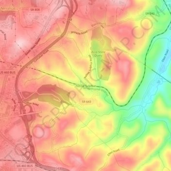
Name: Yellow Sulphur topographic map, elevation, terrain.
Average elevation: 1,949 ft
Minimum elevation: 1,486 ft
Maximum elevation: 2,195 ft
Montgomery County trails, hiking, mountain biking, running and outdoor activities
Make a donation
Gear up for your next adventure:
As an Amazon Associate, this site earns from qualifying purchases at no extra cost to you.
Other topographic maps
Click on a map to view its topography, its elevation and its terrain.
Blacksburg
United States > Virginia > Montgomery County
Blacksburg exhibits a varied topography characterized by its rolling hills and elevation changes. The town is situated at an average elevation of approximately 2,040 feet (621 meters) above sea level, with elevations ranging from about 1,440 feet (440 meters) to peaks reaching approximately 2,800 feet (860…
Average elevation: 2,037 ft
Make a donation
Gear up for your next adventure:
As an Amazon Associate, this site earns from qualifying purchases at no extra cost to you.
Blacksburg
United States > Virginia > Montgomery County
In the mid-1600s, English colonists were still uncertain of what lay beyond the Allegheny Mountains, whose topography and possession by native inhabitants, Tutelo-speaking tribes, were a barrier to expanded settlement by the Colony of Virginia. Abraham Wood, who commanded Fort Henry on the frontier (now the…
Average elevation: 2,037 ft