
Make a donation
Gear up for your next adventure:
As an Amazon Associate, this site earns from qualifying purchases at no extra cost to you.
Asientos topographic map
Click on the map to display elevation.
Make a donation
Gear up for your next adventure:
As an Amazon Associate, this site earns from qualifying purchases at no extra cost to you.
Asientos
The municipality of Asientos is located in the north-east of the state and has a territorial area of 547.74 kilometres squared which is equivalent to 9.84% of the total area of the state and it has an altitude ranging from 1800 to 2700 metres above sea level.
Make a donation
Gear up for your next adventure:
As an Amazon Associate, this site earns from qualifying purchases at no extra cost to you.
About this map
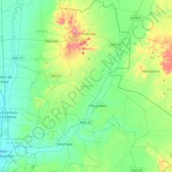
Name: Asientos topographic map, elevation, terrain.
Location: Asientos, Aguascalientes, Mexico (21.95839 -102.21933 22.30607 -101.85416)
Average elevation: 6,699 ft
Minimum elevation: 6,138 ft
Maximum elevation: 8,638 ft
Make a donation
Gear up for your next adventure:
As an Amazon Associate, this site earns from qualifying purchases at no extra cost to you.
Other topographic maps
Click on a map to view its topography, its elevation and its terrain.
Aguascalientes City
Mexico > Aguascalientes > Municipio de Aguascalientes
The Aguascalientes Bicentenary Velodrome, designed by Peter Junek, hosted the 2010 Pan American Track Championships. At an elevation of 1887m, the Velodrome is a frequent location for attempts at breaking the Cycling Hour Record.
Average elevation: 6,417 ft
San Francisco de Los Romo
Mexico > Aguascalientes > San Francisco de los Romo
Average elevation: 6,263 ft
Make a donation
Gear up for your next adventure:
As an Amazon Associate, this site earns from qualifying purchases at no extra cost to you.
Aguascalientes City
Mexico > Aguascalientes > Municipio de Aguascalientes
The Aguascalientes Bicentenary Velodrome, designed by Peter Junek, hosted the 2010 Pan American Track Championships. At an elevation of 1887m, the Velodrome is a frequent location for attempts at breaking the Cycling Hour Record.
Average elevation: 6,417 ft
Make a donation
Gear up for your next adventure:
As an Amazon Associate, this site earns from qualifying purchases at no extra cost to you.
Aguascalientes City
Mexico > Aguascalientes > Municipio de Aguascalientes
The Aguascalientes Bicentenary Velodrome, designed by Peter Junek, hosted the 2010 Pan American Track Championships. At an Elevation of 1887m, the Velodrome is a frequent location for attempts at breaking the Cycling Hour Record
Average elevation: 6,417 ft
Aguascalientes City
Mexico > Aguascalientes > Municipio de Aguascalientes
The Aguascalientes Bicentenary Velodrome, designed by Peter Junek, hosted the 2010 Pan American Track Championships. At an elevation of 1887m, the Velodrome is a frequent location for attempts at breaking the Cycling Hour Record.
Average elevation: 6,417 ft
La Cardona
Mexico > Aguascalientes > Jesús María > Jesús María > La Cardona
Average elevation: 6,132 ft
Make a donation
Gear up for your next adventure:
As an Amazon Associate, this site earns from qualifying purchases at no extra cost to you.