Geolocate

Bad Rothenfelde topographic map

Click on the map to display elevation.

About this map

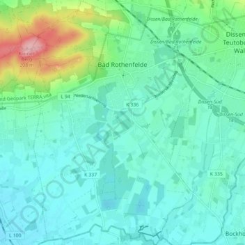
Name: Bad Rothenfelde topographic map, elevation, terrain.

Location: Bad Rothenfelde, Landkreis Osnabrück, Lower Saxony, 49214, Germany (52.07192 8.12984 52.12490 8.18649)

Average elevation: 331 ft

Minimum elevation: 240 ft

Maximum elevation: 692 ft

Other topographic maps

Click on a map to view its topography, its elevation and its terrain.

Borgloh

Germany > Lower Saxony > Landkreis Osnabrück

Average elevation: 417 ft

Boberg

Germany > Lower Saxony > Landkreis Osnabrück > Merzen

Average elevation: 341 ft

Gear up for your next adventure:

🌡️Portable Weather Meter - Track weather conditions on the trail
🔦Powerful Headlamps - Ultra-bright hands-free lighting for night navigation
🔋Solar Power Banks - Keep your GPS and phone charged in remote wilderness areas
🪶Trail Camera - Capture wildlife on your hikes
🧥Men's Rain Shells - Premium waterproof and breathable jackets for mountain weather

As an Amazon Associate, this site earns from qualifying purchases at no extra cost to you.