Geolocate

Borgloh topographic map

Click on the map to display elevation.

About this map

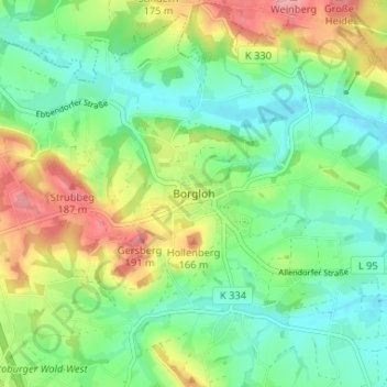
Name: Borgloh topographic map, elevation, terrain.

Location: Borgloh, Hilter, Landkreis Osnabrück, Lower Saxony, 49176, Germany (52.17105 8.16480 52.21105 8.20480)

Average elevation: 417 ft

Minimum elevation: 282 ft

Maximum elevation: 659 ft

Other topographic maps

Click on a map to view its topography, its elevation and its terrain.

Bad Essen

Germany > Lower Saxony > Landkreis Osnabrück

The town of Bad Essen is on the North German Plains, because of the transition of the low mountain range to the plains. The Wiehengebirge Range covers approximately the southern third of the town and reaches an elevation of 211m above sea level. The highest point of the Wiehengebirge Range is on the black…

Average elevation: 259 ft

Bad Iburg

Germany > Lower Saxony > Landkreis Osnabrück

Average elevation: 410 ft

Melle

Germany > Lower Saxony > Landkreis Osnabrück

Average elevation: 384 ft

Alfhausen

Germany > Lower Saxony > Landkreis Osnabrück

Average elevation: 167 ft

Bad Laer

Germany > Lower Saxony > Landkreis Osnabrück

Average elevation: 289 ft

Gear up for your next adventure:

🩹Survival Bandages - High‑quality bandages for emergencies
🧴Hand Sanitizer - Keep hands clean while hiking
🧥Waterproof Jacket for Hiking - Breathable and rugged rain jacket for outdoor excursions
👟Men's Trail Runners - Lightweight footwear for fast-paced exploration and light hiking
🩳Quick‑Dry Hiking Shorts - Comfortable and quick‑dry shorts for summer hiking

As an Amazon Associate, this site earns from qualifying purchases at no extra cost to you.