
Make a donation
Gear up for your next adventure:
As an Amazon Associate, this site earns from qualifying purchases at no extra cost to you.
Colline de l'Abri topographic map
Click on the map to display elevation.
Make a donation
Gear up for your next adventure:
As an Amazon Associate, this site earns from qualifying purchases at no extra cost to you.
About this map
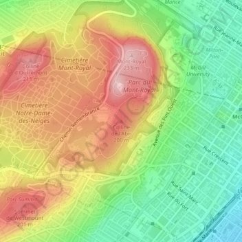
Name: Colline de l'Abri topographic map, elevation, terrain.
Average elevation: 394 ft
Minimum elevation: 52 ft
Maximum elevation: 761 ft
Make a donation
Gear up for your next adventure:
As an Amazon Associate, this site earns from qualifying purchases at no extra cost to you.
Other topographic maps
Click on a map to view its topography, its elevation and its terrain.
Pierrefonds-Roxboro
Canada > Quebec > Urban agglomeration of Montreal > Montreal
Average elevation: 98 ft
Rivière des Prairies
Canada > Quebec > Urban agglomeration of Montreal > Montreal
Average elevation: 112 ft
Make a donation
Gear up for your next adventure:
As an Amazon Associate, this site earns from qualifying purchases at no extra cost to you.
Parc de la Rive-Boisée
Canada > Quebec > Urban agglomeration of Montreal > Montreal
Average elevation: 95 ft
Rivière des Prairies
Canada > Quebec > Urban agglomeration of Montreal > Montreal
Average elevation: 118 ft
Make a donation
Gear up for your next adventure:
As an Amazon Associate, this site earns from qualifying purchases at no extra cost to you.
Notre Dame Island
Canada > Quebec > Urban agglomeration of Montreal > Montreal
Average elevation: 46 ft
Rosemont–La Petite-Patrie
Canada > Quebec > Urban agglomeration of Montreal > Montreal
Average elevation: 164 ft
Make a donation
Gear up for your next adventure:
As an Amazon Associate, this site earns from qualifying purchases at no extra cost to you.
Parc Léon-Provancher
Canada > Quebec > Urban agglomeration of Montreal > Montreal
Average elevation: 174 ft
Saint Helen's Island
Canada > Quebec > Urban agglomeration of Montreal > Montreal
Average elevation: 49 ft
Le Plateau-Mont-Royal
Canada > Quebec > Urban agglomeration of Montreal > Montreal
Average elevation: 230 ft
Make a donation
Gear up for your next adventure:
As an Amazon Associate, this site earns from qualifying purchases at no extra cost to you.
Parc-nature du Bois-de-Liesse
Canada > Quebec > Urban agglomeration of Montreal > Montreal
Average elevation: 92 ft
Make a donation
Gear up for your next adventure:
As an Amazon Associate, this site earns from qualifying purchases at no extra cost to you.
Make a donation
Gear up for your next adventure:
As an Amazon Associate, this site earns from qualifying purchases at no extra cost to you.
Victoria Square
Canada > Quebec > Urban agglomeration of Montreal > Montreal
Average elevation: 102 ft