Geolocate

Stanley topographic map

Click on the map to display elevation.

About this map

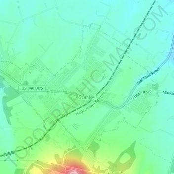
Name: Stanley topographic map, elevation, terrain.

Location: Stanley, Page County, Virginia, United States (38.56592 -78.52798 38.58807 -78.48668)

Average elevation: 1,076 ft

Minimum elevation: 906 ft

Maximum elevation: 1,608 ft

Page County trails, hiking, mountain biking, running and outdoor activities

Other topographic maps

Click on a map to view its topography, its elevation and its terrain.

Stony Man

United States > Virginia > Page County

Average elevation: 3,156 ft

Grove Hill

United States > Virginia > Page County

Average elevation: 961 ft

Skyland

United States > Virginia > Page County

Average elevation: 2,812 ft

Luray

United States > Virginia > Page County

Average elevation: 873 ft

Vaughn

United States > Virginia > Page County > Vaughn

Average elevation: 997 ft

Ingham

United States > Virginia > Page County > Ingham

Average elevation: 1,184 ft

Mauck

United States > Virginia > Page County

Average elevation: 1,535 ft

Fairview

United States > Virginia > Page County > Luray

Average elevation: 928 ft

Gear up for your next adventure:

🕶️GPS Smartphone Mount - Secure mount for phone navigation
🧤Tactile Hiking Gloves - Keep hands warm while operating GPS and smartphone screens
🔭Compact Binoculars - HD vision for scouting terrain and identifying distant landmarks
👟Trail Running Shoes - Lightweight shoes for trail runners
🛠️Backpacking Tool Kit - Essential toolkit for outdoor repairs

As an Amazon Associate, this site earns from qualifying purchases at no extra cost to you.