Geolocate

Bari topographic map

Click on the map to display elevation.

About this map

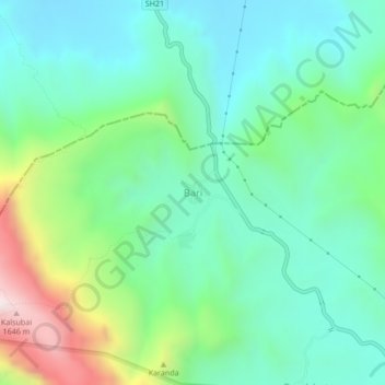
Name: Bari topographic map, elevation, terrain.

Location: Bari, Akola, Ahmednagar District, Maharashtra, India (19.59285 73.71046 19.63285 73.75046)

Average elevation: 3,002 ft

Minimum elevation: 2,162 ft

Maximum elevation: 5,305 ft

Other topographic maps

Click on a map to view its topography, its elevation and its terrain.

Borgaon Manju

India > Maharashtra > Akola

Average elevation: 968 ft

Babhulgaon

India > Maharashtra > Akola > Babhulgaon

Average elevation: 965 ft

Dongargaon

India > Maharashtra > Akola > Dongargaon

Average elevation: 965 ft

Pahadpur

India > Maharashtra > Akola

Average elevation: 981 ft

Nawakheda

India > Maharashtra > Akola

Average elevation: 886 ft

Nizampur

India > Maharashtra > Akola

Average elevation: 919 ft

Hingna Barling

India > Maharashtra > Akola

Average elevation: 938 ft

Kothari

India > Maharashtra > Akola

Average elevation: 981 ft

Gear up for your next adventure:

🪶Wildlife Field Guides - Learn animal tracking and species ID
🔦Powerful Headlamps - Ultra-bright hands-free lighting for night navigation
🔥Fast-Boil Camping Stoves - Efficient cooking systems for quick trail meals
👖Convertible Hiking Pants - Versatile zip-off pants for changing altitudes and temperatures
🧣Hiking Neck Gaiter - Multi‑use neck protection for outdoor weather

As an Amazon Associate, this site earns from qualifying purchases at no extra cost to you.