
Make a donation
Gear up for your next adventure:
As an Amazon Associate, this site earns from qualifying purchases at no extra cost to you.
Sundown topographic map
Click on the map to display elevation.
Make a donation
Gear up for your next adventure:
As an Amazon Associate, this site earns from qualifying purchases at no extra cost to you.
About this map
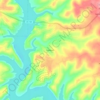
Name: Sundown topographic map, elevation, terrain.
Location: Sundown, Ozark County, Missouri, 65676, United States (36.54645 -92.65683 36.58645 -92.61683)
Average elevation: 778 ft
Minimum elevation: 617 ft
Maximum elevation: 988 ft
Ozark County trails, hiking, mountain biking, running and outdoor activities
Make a donation
Gear up for your next adventure:
As an Amazon Associate, this site earns from qualifying purchases at no extra cost to you.
Other topographic maps
Click on a map to view its topography, its elevation and its terrain.
Bull Shoals Lake
United States > Missouri > Ozark County > Theodosia
Bull Shoals Lake impounds the White River for the last time as water travels toward its mouth on the Mississippi River. Bull Shoals is thus the lake farthest downstream in a chain of four artificial lakes that include (from upstream to downstream) Beaver Lake, Table Rock Lake and Lake Taneycomo. The lake is…
Average elevation: 919 ft