
Make a donation
Gear up for your next adventure:
As an Amazon Associate, this site earns from qualifying purchases at no extra cost to you.
Sennhof topographic map
Click on the map to display elevation.
Make a donation
Gear up for your next adventure:
As an Amazon Associate, this site earns from qualifying purchases at no extra cost to you.
About this map
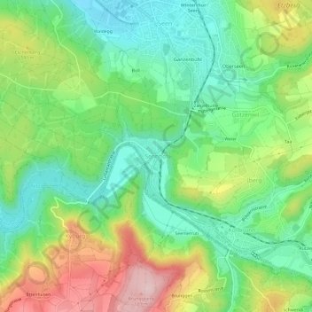
Name: Sennhof topographic map, elevation, terrain.
Location: Sennhof, Winterthur, Bezirk Winterthur, Zürich, 8482, Schweiz (47.44733 8.73976 47.48733 8.77976)
Average elevation: 1,772 ft
Minimum elevation: 1,467 ft
Maximum elevation: 2,283 ft
Make a donation
Gear up for your next adventure:
As an Amazon Associate, this site earns from qualifying purchases at no extra cost to you.
Other topographic maps
Click on a map to view its topography, its elevation and its terrain.
Wülflingen
Schweiz > Zürich > Bezirk Winterthur > Winterthur
Vereinzelte Funde auf dem Gebiet Wülflingens datieren bis auf die Steinzeit zurück, jedoch gibt es auch in dieser Zeit noch keine Spuren einer festen Besiedlung. In der Bronzezeit verdichten sich die Fundbestände bereits, beim 1822 erfolgten Bau der Spinnerei Beugger wurde ein Depotfund aus diesem Zeitraum…
Average elevation: 1,555 ft