Geolocate

Byers topographic map

Click on the map to display elevation.

About this map

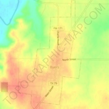
Name: Byers topographic map, elevation, terrain.

Location: Byers, Clay County, Texas, 76357, United States (34.05729 -98.20279 34.08646 -98.18239)

Average elevation: 981 ft

Minimum elevation: 879 ft

Maximum elevation: 1,040 ft

Clay County trails, hiking, mountain biking, running and outdoor activities

Other topographic maps

Click on a map to view its topography, its elevation and its terrain.

Charlie

United States > Texas > Clay County

Average elevation: 951 ft

Walton

United States > Texas > Clay County

Average elevation: 883 ft

Shannon

United States > Texas > Clay County

Average elevation: 1,053 ft

Gear up for your next adventure:

Solar GPS Watches - Advanced multisport watches with built-in topographic maps
🧭GPS Watch Accessories - Bands and chargers for GPS watches
☀️Outdoor Sunscreen - High protection sunscreen for outdoor activities
🧯Portable Fire Pit - Compact fire pit for camping spots
🎁Geography Themed Gifts - Unique gift ideas for map lovers and geography enthusiasts

As an Amazon Associate, this site earns from qualifying purchases at no extra cost to you.