
Make a donation
Gear up for your next adventure:
As an Amazon Associate, this site earns from qualifying purchases at no extra cost to you.
Sipapu topographic map
Click on the map to display elevation.
Make a donation
Gear up for your next adventure:
As an Amazon Associate, this site earns from qualifying purchases at no extra cost to you.
Sipapu
Sipapu Ski & Summer Resort, also known simply as Sipapu, is a moderately sized ski resort in Taos County, New Mexico. It is home to New Mexico's longest ski season, from November to April. The peak elevation is 9,255 ft (2,821 m). There are 41 trails and 6 lifts. Other facilities include 4 terrain parks, golf, fishing, lodge accommodations and restaurants. It is located in the Carson National Forest, about 20 miles south-southeast of Taos, New Mexico.
Make a donation
Gear up for your next adventure:
As an Amazon Associate, this site earns from qualifying purchases at no extra cost to you.
About this map
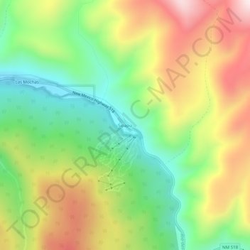
Name: Sipapu topographic map, elevation, terrain.
Location: Sipapu, Taos County, New Mexico, United States (36.13558 -105.57057 36.17558 -105.53057)
Average elevation: 9,035 ft
Minimum elevation: 8,045 ft
Maximum elevation: 10,312 ft
Taos County trails, hiking, mountain biking, running and outdoor activities
Make a donation
Gear up for your next adventure:
As an Amazon Associate, this site earns from qualifying purchases at no extra cost to you.
Other topographic maps
Click on a map to view its topography, its elevation and its terrain.
Taos Ski Valley
United States > New Mexico > Taos County
Taos Ski Valley is a village and alpine ski resort in the southwestern United States, located in Taos County, New Mexico. The population was 69 at the 2010 census. Until March 19, 2008, it was one of four ski resorts in America to prohibit snowboarding. The Kachina lift, constructed in 2014, serves one of the…
Average elevation: 10,850 ft