
Huggate topographic map
Click on the map to display elevation.
About this map
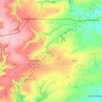
Name: Huggate topographic map, elevation, terrain.
Average elevation: 430 ft
Minimum elevation: 135 ft
Maximum elevation: 728 ft
Other topographic maps
Click on a map to view its topography, its elevation and its terrain.
Little Driffield
United Kingdom > England > East Riding of Yorkshire > Driffield
Average elevation: 98 ft
East Cottingwith
United Kingdom > England > East Riding of Yorkshire > East Cottingwith
Average elevation: 26 ft
Malton Lane Plantation
United Kingdom > England > East Riding of Yorkshire > Bugthorpe
Average elevation: 177 ft
Burton Constable Hall
United Kingdom > England > East Riding of Yorkshire > West Newton
Average elevation: 59 ft
Willerby and Derringham Flood Alleviation Scheme
United Kingdom > England > East Riding of Yorkshire > Kirk Ella
Average elevation: 138 ft