
Make a donation
Gear up for your next adventure:
As an Amazon Associate, this site earns from qualifying purchases at no extra cost to you.
Machachi topographic map
Click on the map to display elevation.
Make a donation
Gear up for your next adventure:
As an Amazon Associate, this site earns from qualifying purchases at no extra cost to you.
Machachi
Machachi is located to the south of the capital of Ecuador, Quito. It is a very beautiful city surrounded by the volcanos Atacazo, Corazon, Rumiñahui, Illinizas peaks, Viudita hill, Pasochoa, Sincholagua and is also owns part of the Cotopaxi volcano, a great active volcano which measures 5,897 m (19,347 ft) in altitude. The valley contains 8 volcanoes, the reasons why Alexander von Humboldt named the region Avenue of Volcanoes.
Make a donation
Gear up for your next adventure:
As an Amazon Associate, this site earns from qualifying purchases at no extra cost to you.
About this map
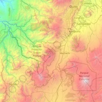
Name: Machachi topographic map, elevation, terrain.
Location: Machachi, Pichincha, Ecuador (-0.72106 -78.95442 -0.27596 -78.32060)
Average elevation: 9,639 ft
Minimum elevation: 2,224 ft
Maximum elevation: 19,147 ft
Make a donation
Gear up for your next adventure:
As an Amazon Associate, this site earns from qualifying purchases at no extra cost to you.
Other topographic maps
Click on a map to view its topography, its elevation and its terrain.
Make a donation
Gear up for your next adventure:
As an Amazon Associate, this site earns from qualifying purchases at no extra cost to you.
Volcán Cotopaxi
Ecuador > Pichincha > Machachi > Machachi
In the late 20th century, summiting Cotopaxi became a major tourist draw. The José F. Ribas Refuge (Refugio José Félix Ribas) was built in 1971 at an elevation of 4,864 m (15,960 ft) and enlarged in 2005.
Average elevation: 16,473 ft
Make a donation
Gear up for your next adventure:
As an Amazon Associate, this site earns from qualifying purchases at no extra cost to you.