
Make a donation
Gear up for your next adventure:
As an Amazon Associate, this site earns from qualifying purchases at no extra cost to you.
Feckenham topographic map
Click on the map to display elevation.
Make a donation
Gear up for your next adventure:
As an Amazon Associate, this site earns from qualifying purchases at no extra cost to you.
About this map
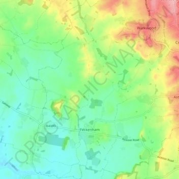
Name: Feckenham topographic map, elevation, terrain.
Location: Feckenham, Redditch, Worcestershire, England, United Kingdom (52.23525 -2.01894 52.29204 -1.96039)
Average elevation: 285 ft
Minimum elevation: 151 ft
Maximum elevation: 541 ft
Make a donation
Gear up for your next adventure:
As an Amazon Associate, this site earns from qualifying purchases at no extra cost to you.
Other topographic maps
Click on a map to view its topography, its elevation and its terrain.
Morton Stanley Park
United Kingdom > England > Worcestershire > Redditch > Callow Hill
Average elevation: 423 ft
Arrow Valley Country Park
United Kingdom > England > Worcestershire > Redditch
Average elevation: 285 ft
Elcocks Brook
United Kingdom > England > Worcestershire > Redditch > Feckenham
Average elevation: 331 ft
Make a donation
Gear up for your next adventure:
As an Amazon Associate, this site earns from qualifying purchases at no extra cost to you.