
Worthington topographic map
Interactive map
Click on the map to display elevation.
About this map
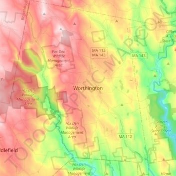
Name: Worthington topographic map, elevation, terrain.
Location: Worthington, Hampshire County, Massachusetts, United States (42.33149 -73.00908 42.44909 -72.88081)
Average elevation: 1,348 ft
Minimum elevation: 597 ft
Maximum elevation: 2,011 ft
Hampshire County trails, hiking, mountain biking, running and outdoor activities
Other topographic maps
Click on a map to view its topography, its elevation and its terrain.
Amherst Woods
United States > Massachusetts > Hampshire County > Amherst > Amherst Woods
Average elevation: 276 ft
Brown Ellison Park
United States > Massachusetts > Hampshire County > Granby
Average elevation: 282 ft