Geolocate

Newton topographic map

Click on the map to display elevation.

About this map

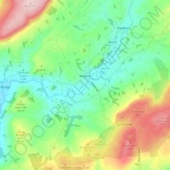
Name: Newton topographic map, elevation, terrain.

Location: Newton, Ribble Valley, Lancashire, England, United Kingdom (53.91453 -2.51547 53.97708 -2.40594)

Average elevation: 732 ft

Minimum elevation: 358 ft

Maximum elevation: 1,421 ft

Other topographic maps

Click on a map to view its topography, its elevation and its terrain.

Hareden

United Kingdom > England > Lancashire > Ribble Valley

Average elevation: 837 ft

Horton

United Kingdom > England > Lancashire > Ribble Valley

Average elevation: 495 ft

Whitewell

United Kingdom > England > Lancashire > Ribble Valley

Average elevation: 604 ft

Billington

United Kingdom > England > Lancashire > Ribble Valley

Average elevation: 292 ft

Hesketh Lane

United Kingdom > England > Lancashire > Ribble Valley

Average elevation: 430 ft

Dunsop Bridge

United Kingdom > England > Lancashire > Ribble Valley

Average elevation: 643 ft

Gisburn

United Kingdom > England > Lancashire > Ribble Valley

Average elevation: 479 ft

Tosside

United Kingdom > England > Lancashire > Ribble Valley

Average elevation: 781 ft

Jamacia Wood

United Kingdom > England > Lancashire > Ribble Valley > Langho

Average elevation: 328 ft

Bowland Knotts

United Kingdom > England > Lancashire > Ribble Valley

Average elevation: 1,135 ft

Tooth Hill

United Kingdom > England > Lancashire > Ribble Valley

Average elevation: 1,214 ft

Jamacia Wood

United Kingdom > England > Lancashire > Ribble Valley > Langho

Average elevation: 328 ft

Gear up for your next adventure:

🔊Portable Camp Speaker - Music and alerts at camp
🧼Biodegradable Camping Soap - Eco‑friendly soap for outdoor hygiene
🧯Portable Fire Pit - Compact fire pit for camping spots
📌Outdoor GPS Map App - Apps and devices for digital topographic navigation
🚁Photography Drones - Capture stunning aerial views of landforms and topography

As an Amazon Associate, this site earns from qualifying purchases at no extra cost to you.