
Mount Kidd RV Park topographic map
Click on the map to display elevation.
About this map
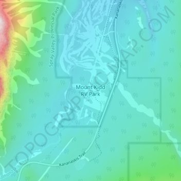
Name: Mount Kidd RV Park topographic map, elevation, terrain.
Average elevation: 5,161 ft
Minimum elevation: 4,764 ft
Maximum elevation: 7,749 ft
Other topographic maps
Click on a map to view its topography, its elevation and its terrain.
Bow Valley Provincial Park
Canada > Alberta > Kananaskis Improvement District
Average elevation: 5,594 ft
Peter Lougheed Provincial Park
Canada > Alberta > Kananaskis Improvement District
Average elevation: 7,156 ft
West Bragg Creek Provincial Recreation Area
Canada > Alberta > Kananaskis Improvement District
Average elevation: 4,813 ft
Little Elbow Campground
Canada > Alberta > Kananaskis Improvement District
Average elevation: 5,502 ft