
Make a donation
Gear up for your next adventure:
As an Amazon Associate, this site earns from qualifying purchases at no extra cost to you.
Ledyard topographic map
Click on the map to display elevation.
Make a donation
Gear up for your next adventure:
As an Amazon Associate, this site earns from qualifying purchases at no extra cost to you.
About this map
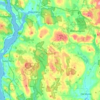
Name: Ledyard topographic map, elevation, terrain.
Average elevation: 174 ft
Minimum elevation: -10 ft
Maximum elevation: 495 ft
Make a donation
Gear up for your next adventure:
As an Amazon Associate, this site earns from qualifying purchases at no extra cost to you.
Other topographic maps
Click on a map to view its topography, its elevation and its terrain.
High Rock
United States > Connecticut > Southeastern Connecticut Planning Region > Waterford
Average elevation: 128 ft
Chesterfield
United States > Connecticut > Southeastern Connecticut Planning Region > Montville
Average elevation: 253 ft
North Franklin
United States > Connecticut > Southeastern Connecticut Planning Region
Average elevation: 338 ft
Mystic
United States > Connecticut > Southeastern Connecticut Planning Region
Average elevation: 79 ft
Make a donation
Gear up for your next adventure:
As an Amazon Associate, this site earns from qualifying purchases at no extra cost to you.
Flanders
United States > Connecticut > Southeastern Connecticut Planning Region > East Lyme
Average elevation: 141 ft
Manitock Spring
United States > Connecticut > Southeastern Connecticut Planning Region > Waterford
Average elevation: 85 ft
Quiambaug
United States > Connecticut > Southeastern Connecticut Planning Region > Mystic
Average elevation: 26 ft
Oakdale
United States > Connecticut > Southeastern Connecticut Planning Region > Montville
Average elevation: 463 ft
Make a donation
Gear up for your next adventure:
As an Amazon Associate, this site earns from qualifying purchases at no extra cost to you.
Austrailia Beach
United States > Connecticut > Southeastern Connecticut Planning Region > Mystic
Average elevation: 62 ft
Jordan Village
United States > Connecticut > Southeastern Connecticut Planning Region > Waterford
Average elevation: 89 ft
Giants Neck
United States > Connecticut > Southeastern Connecticut Planning Region > East Lyme
Average elevation: 30 ft
Pepperbox Hill
United States > Connecticut > Southeastern Connecticut Planning Region > Waterford
Average elevation: 59 ft
Make a donation
Gear up for your next adventure:
As an Amazon Associate, this site earns from qualifying purchases at no extra cost to you.
Austrailia Beach
United States > Connecticut > Southeastern Connecticut Planning Region > Mystic
Average elevation: 62 ft
Montville Center
United States > Connecticut > Southeastern Connecticut Planning Region > Montville
Average elevation: 348 ft
Four Corners
United States > Connecticut > Southeastern Connecticut Planning Region > Montville
Average elevation: 354 ft
Taftville Reservoir #1 Dam
United States > Connecticut > Southeastern Connecticut Planning Region > Norwich
Average elevation: 246 ft
Make a donation
Gear up for your next adventure:
As an Amazon Associate, this site earns from qualifying purchases at no extra cost to you.
Mystic
United States > Connecticut > Southeastern Connecticut Planning Region
Average elevation: 79 ft
Blue Lake
United States > Connecticut > Southeastern Connecticut Planning Region > North Stonington
Average elevation: 348 ft
Blackboys
United States > Connecticut > Southeastern Connecticut Planning Region > East Lyme
Average elevation: 125 ft
Quiambaug
United States > Connecticut > Southeastern Connecticut Planning Region > Mystic
Average elevation: 26 ft
Make a donation
Gear up for your next adventure:
As an Amazon Associate, this site earns from qualifying purchases at no extra cost to you.
Quaker Hill
United States > Connecticut > Southeastern Connecticut Planning Region > Waterford
Average elevation: 115 ft
Center Groton
United States > Connecticut > Southeastern Connecticut Planning Region > Groton
Average elevation: 161 ft
Uncasville
United States > Connecticut > Southeastern Connecticut Planning Region > Montville
Average elevation: 131 ft
Chesterfield
United States > Connecticut > Southeastern Connecticut Planning Region > Montville
Average elevation: 253 ft
Make a donation
Gear up for your next adventure:
As an Amazon Associate, this site earns from qualifying purchases at no extra cost to you.
Austrailia Beach
United States > Connecticut > Southeastern Connecticut Planning Region > Mystic
Average elevation: 62 ft
Flanders
United States > Connecticut > Southeastern Connecticut Planning Region > East Lyme
Average elevation: 141 ft
Huntley Island
United States > Connecticut > Southeastern Connecticut Planning Region > East Lyme
Average elevation: 23 ft
Austrailia Beach
United States > Connecticut > Southeastern Connecticut Planning Region > Mystic
Average elevation: 62 ft
Make a donation
Gear up for your next adventure:
As an Amazon Associate, this site earns from qualifying purchases at no extra cost to you.
Hanover Reservoir
United States > Connecticut > Southeastern Connecticut Planning Region > Hanover
Average elevation: 299 ft
North Stonington
United States > Connecticut > Southeastern Connecticut Planning Region
Average elevation: 240 ft
Mystic
United States > Connecticut > Southeastern Connecticut Planning Region > Stonington
Average elevation: 56 ft
Avery Hill
United States > Connecticut > Southeastern Connecticut Planning Region > Ledyard
Average elevation: 171 ft
Make a donation
Gear up for your next adventure:
As an Amazon Associate, this site earns from qualifying purchases at no extra cost to you.
Fitch Corner
United States > Connecticut > Southeastern Connecticut Planning Region > Montville
Average elevation: 167 ft
Seal Rocks
United States > Connecticut > Southeastern Connecticut Planning Region > Stonington
Average elevation: 121 ft