
Make a donation
Gear up for your next adventure:
As an Amazon Associate, this site earns from qualifying purchases at no extra cost to you.
Columbia topographic map
Click on the map to display elevation.
Make a donation
Gear up for your next adventure:
As an Amazon Associate, this site earns from qualifying purchases at no extra cost to you.
Columbia
Columbia features a relatively gentle and rolling topography. The elevation in this area varies, with the city itself situated around 318 feet above sea level, while the surrounding regions exhibit elevations that can reach as high as 573 feet. The landscape is characterized by a mix of low-lying areas and rolling hills, primarily shaped by the confluence of the Saluda and Broad Rivers, which contribute to the area's hydrology and ecological diversity. Richland County encompasses a total area of about 772 square miles, of which a small fraction is covered by water, highlighting its predominantly land-based terrain. The terrain supports a range of habitats and is interspersed with various parks and protected areas, such as Congaree National Park and Harbison State Forest, adding to the natural beauty of the region.
Make a donation
Gear up for your next adventure:
As an Amazon Associate, this site earns from qualifying purchases at no extra cost to you.
About this map
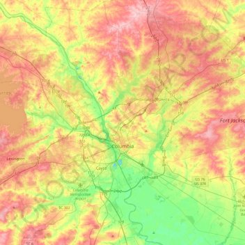
Name: Columbia topographic map, elevation, terrain.
Location: Columbia, Richland County, South Carolina, United States (33.94325 -81.17098 34.13160 -80.70382)
Average elevation: 292 ft
Minimum elevation: 43 ft
Maximum elevation: 571 ft
Richland County trails, hiking, mountain biking, running and outdoor activities
Make a donation
Gear up for your next adventure:
As an Amazon Associate, this site earns from qualifying purchases at no extra cost to you.
Other topographic maps
Click on a map to view its topography, its elevation and its terrain.
Forest I At Harbison
United States > South Carolina > Richland County > Columbia
Average elevation: 285 ft
Make a donation
Gear up for your next adventure:
As an Amazon Associate, this site earns from qualifying purchases at no extra cost to you.
Make a donation
Gear up for your next adventure:
As an Amazon Associate, this site earns from qualifying purchases at no extra cost to you.
Sesquicentennial State Park
United States > South Carolina > Richland County
This park offers three picnic shelters, four picnic pads, and 84 campsites that vary in amenities & sizes. The park provides rental fishing boats, paddle boats, standup paddleboards, kayaks, canoes, fishing access to the 30-acre (12 ha) park lake, and four trails providing over 12 miles (19 km) of recreational…
Average elevation: 318 ft
Harbison State Forest
United States > South Carolina > Richland County > Columbia
Average elevation: 259 ft
Forest I At Harbison
United States > South Carolina > Richland County > Columbia
Average elevation: 285 ft
Riverbanks
United States > South Carolina > Richland County > Columbia > Riverbanks
Average elevation: 226 ft
Make a donation
Gear up for your next adventure:
As an Amazon Associate, this site earns from qualifying purchases at no extra cost to you.
Lincolnshire
United States > South Carolina > Richland County > Lincolnshire
Average elevation: 262 ft