
Make a donation
Gear up for your next adventure:
As an Amazon Associate, this site earns from qualifying purchases at no extra cost to you.
Lake Columbia topographic map
Click on the map to display elevation.
Make a donation
Gear up for your next adventure:
As an Amazon Associate, this site earns from qualifying purchases at no extra cost to you.
About this map
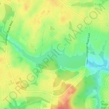
Name: Lake Columbia topographic map, elevation, terrain.
Average elevation: 397 ft
Minimum elevation: 305 ft
Maximum elevation: 482 ft
Make a donation
Gear up for your next adventure:
As an Amazon Associate, this site earns from qualifying purchases at no extra cost to you.
Other topographic maps
Click on a map to view its topography, its elevation and its terrain.
Columbia
United States > South Carolina > Richland County
Columbia features a relatively gentle and rolling topography. The elevation in this area varies, with the city itself situated around 318 feet above sea level, while the surrounding regions exhibit elevations that can reach as high as 573 feet. The landscape is characterized by a mix of low-lying areas and…
Average elevation: 292 ft
Forest I At Harbison
United States > South Carolina > Richland County > Columbia
Average elevation: 285 ft
Make a donation
Gear up for your next adventure:
As an Amazon Associate, this site earns from qualifying purchases at no extra cost to you.
Columbia
United States > South Carolina > Richland County
The city has capitalized on this location, which includes three rivers, by identifying as "The Columbia Riverbanks Region". Columbia is located roughly halfway between the Atlantic Ocean and the Blue Ridge Mountains, at an elevation around 292 ft (89 m).
Average elevation: 292 ft
Forest I At Harbison
United States > South Carolina > Richland County > Columbia
Average elevation: 285 ft
Make a donation
Gear up for your next adventure:
As an Amazon Associate, this site earns from qualifying purchases at no extra cost to you.
Riverbanks
United States > South Carolina > Richland County > Columbia > Riverbanks
Average elevation: 226 ft
Lincolnshire
United States > South Carolina > Richland County > Lincolnshire
Average elevation: 262 ft