
Make a donation
Gear up for your next adventure:
As an Amazon Associate, this site earns from qualifying purchases at no extra cost to you.
Rushton topographic map
Click on the map to display elevation.
Make a donation
Gear up for your next adventure:
As an Amazon Associate, this site earns from qualifying purchases at no extra cost to you.
About this map
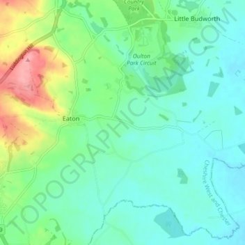
Name: Rushton topographic map, elevation, terrain.
Location: Rushton, Cheshire West and Chester, England, United Kingdom (53.14446 -2.66166 53.18592 -2.58871)
Average elevation: 220 ft
Minimum elevation: 131 ft
Maximum elevation: 476 ft
Make a donation
Gear up for your next adventure:
As an Amazon Associate, this site earns from qualifying purchases at no extra cost to you.
Other topographic maps
Click on a map to view its topography, its elevation and its terrain.
Make a donation
Gear up for your next adventure:
As an Amazon Associate, this site earns from qualifying purchases at no extra cost to you.
Dutton Locks
United Kingdom > England > Cheshire West and Chester > Acton Bridge > Dutton
Average elevation: 92 ft
Countess of Chester Country Park
United Kingdom > England > Cheshire West and Chester > Chester
Average elevation: 69 ft
River Mersey
United Kingdom > England > Cheshire West and Chester > Bromborough
Average elevation: 26 ft
Make a donation
Gear up for your next adventure:
As an Amazon Associate, this site earns from qualifying purchases at no extra cost to you.
Delamere Forest
United Kingdom > England > Cheshire West and Chester
This part of Delamere Forest is undulating in character, with elevations predominantly in the range 60–90 metres. It is composed of numerous hummocks and peatland basins, some of which are glacial in origin while others have been created by sand extraction. The basins form lakes and mosses (bogs) within the…
Average elevation: 295 ft
Bolesworth Castle
United Kingdom > England > Cheshire West and Chester > Harthill > Broxton
Average elevation: 262 ft
Bolesworth Fish Pond
United Kingdom > England > Cheshire West and Chester > Harthill > Broxton
Average elevation: 246 ft
Make a donation
Gear up for your next adventure:
As an Amazon Associate, this site earns from qualifying purchases at no extra cost to you.
Wirral Country Park
United Kingdom > England > Cheshire West and Chester > Neston > Windle Hill
Average elevation: 161 ft
Make a donation
Gear up for your next adventure:
As an Amazon Associate, this site earns from qualifying purchases at no extra cost to you.
Beeston Castle
United Kingdom > England > Cheshire West and Chester > Beeston
Average elevation: 197 ft
Make a donation
Gear up for your next adventure:
As an Amazon Associate, this site earns from qualifying purchases at no extra cost to you.
Peckforton Castle
United Kingdom > England > Cheshire West and Chester > Beeston
Peckforton Castle stands in a wooded area near the northern extremity of Peckforton Hills at an elevation of 469.2 feet (143 m). The land falls steeply downwards to the north and the west of the castle, and the Sandstone Trail, a long-distance footpath, runs along the base of these slopes. The ruins of Beeston…
Average elevation: 272 ft
Make a donation
Gear up for your next adventure:
As an Amazon Associate, this site earns from qualifying purchases at no extra cost to you.
Eddisbury Hill
United Kingdom > England > Cheshire West and Chester > Delamere
Average elevation: 338 ft
Dutton Small Lock (Disused)
United Kingdom > England > Cheshire West and Chester > Acton Bridge > Dutton
Average elevation: 92 ft
Make a donation
Gear up for your next adventure:
As an Amazon Associate, this site earns from qualifying purchases at no extra cost to you.
Broken Cross
United Kingdom > England > Cheshire West and Chester > Lostock Green
Average elevation: 92 ft
Oldcastle Heath
United Kingdom > England > Cheshire West and Chester > Malpas
Average elevation: 253 ft
Stamford Bridge
United Kingdom > England > Cheshire West and Chester > Great Barrow
Average elevation: 79 ft
Make a donation
Gear up for your next adventure:
As an Amazon Associate, this site earns from qualifying purchases at no extra cost to you.
Eddisbury Hill Fort
United Kingdom > England > Cheshire West and Chester > Delamere
Average elevation: 338 ft
Make a donation
Gear up for your next adventure:
As an Amazon Associate, this site earns from qualifying purchases at no extra cost to you.
Bostock Green
United Kingdom > England > Cheshire West and Chester > Bostock Green
Average elevation: 118 ft
Make a donation
Gear up for your next adventure:
As an Amazon Associate, this site earns from qualifying purchases at no extra cost to you.
Brown Heath
United Kingdom > England > Cheshire West and Chester > Brown Heath
Average elevation: 98 ft
Meadowbank
United Kingdom > England > Cheshire West and Chester > Winsford > Meadowbank
Average elevation: 131 ft
Chester Castle
United Kingdom > England > Cheshire West and Chester > Chester
Average elevation: 59 ft
Make a donation
Gear up for your next adventure:
As an Amazon Associate, this site earns from qualifying purchases at no extra cost to you.
Delamere Forest
United Kingdom > England > Cheshire West and Chester
This part of Delamere Forest is undulating in character, with elevations predominantly in the range 60–90 metres. It is composed of numerous hummocks and peatland basins, some of which are glacial in origin while others have been created by sand extraction. The basins form lakes and mosses (bogs) within the…
Average elevation: 295 ft
Make a donation
Gear up for your next adventure:
As an Amazon Associate, this site earns from qualifying purchases at no extra cost to you.
Make a donation
Gear up for your next adventure:
As an Amazon Associate, this site earns from qualifying purchases at no extra cost to you.
Black Diamond Park
United Kingdom > England > Cheshire West and Chester > Chester
Average elevation: 69 ft