
Make a donation
Gear up for your next adventure:
As an Amazon Associate, this site earns from qualifying purchases at no extra cost to you.
Eibach topographic map
Click on the map to display elevation.
Make a donation
Gear up for your next adventure:
As an Amazon Associate, this site earns from qualifying purchases at no extra cost to you.
About this map
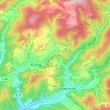
Name: Eibach topographic map, elevation, terrain.
Location: Eibach, Dillenburg, Lahn-Dill-Kreis, Hessen, 35689, Deutschland (50.73376 8.30591 50.76439 8.37255)
Average elevation: 1,181 ft
Minimum elevation: 774 ft
Maximum elevation: 1,673 ft
Make a donation
Gear up for your next adventure:
As an Amazon Associate, this site earns from qualifying purchases at no extra cost to you.
Other topographic maps
Click on a map to view its topography, its elevation and its terrain.
Laufdorf
Deutschland > Hessen > Lahn-Dill-Kreis
Der Ort liegt im Norden des östlichen Hintertaunus und zählt zum Wetzlarer Hintertaunus. Gleichzeitig gehört Laufdorf zum Naturpark Taunus. Die Ortschaft liegt auf einer Anhöhe zwischen Solmsbach und Wetzbach, die sie sich mit dem südlicher gelegenen Nachbarort Schwalbach teilt. Bei Laufdorf entspringt…
Average elevation: 814 ft
Make a donation
Gear up for your next adventure:
As an Amazon Associate, this site earns from qualifying purchases at no extra cost to you.
Knoten
Deutschland > Hessen > Lahn-Dill-Kreis > Arborn
Im Jahr 2013 wurden auf dem Knoten in der Gemarkung von Arborn vier Windkraftanlagen vom Typ E 101 mit einer Nabenhöhe von 135 m errichtet. Um den Bau dieser Anlagen zu verhindern, hatte sich 2010 die Bürgerinitiative Rettet den Knoten gegründet, deren Bemühungen jedoch erfolglos blieben. Aufgrund eines in…
Average elevation: 1,726 ft
Make a donation
Gear up for your next adventure:
As an Amazon Associate, this site earns from qualifying purchases at no extra cost to you.
Wetzlar
Deutschland > Hessen > Lahn-Dill-Kreis > Wetzlar > Wetzlar
Wetzlars wirtschaftliche Bedeutung beruht auf seiner optischen, feinmechanischen, elektrotechnischen und stahlverarbeitenden Industrie. Wetzlar ist als Sportstadt mit bedeutenden Sportlern, Sportveranstaltungen und -vereinen bekannt. Es spielen einige Mannschaften in den jeweiligen Bundesligen. Zur sportlichen…
Average elevation: 712 ft
Ewersbach
Deutschland > Hessen > Lahn-Dill-Kreis
Im Bereich der Gemeinde Ewersbach lagen folgende bekannte Wüstungen: Auf dem Hof (heute Gabelung des Weges zum Tennisplatz und der Straße nach Weidelbach); Grube Thomas (Bergwerksiedlung); das Malerhaus; Odolphausen (etwa in der Höhe des Industriegebiets „In der Heg“); Fackenroth (in der Nähe der…
Average elevation: 1,365 ft
Make a donation
Gear up for your next adventure:
As an Amazon Associate, this site earns from qualifying purchases at no extra cost to you.
Make a donation
Gear up for your next adventure:
As an Amazon Associate, this site earns from qualifying purchases at no extra cost to you.
Make a donation
Gear up for your next adventure:
As an Amazon Associate, this site earns from qualifying purchases at no extra cost to you.
Hunsbach
Deutschland > Hessen > Lahn-Dill-Kreis > Dillenburg > Frohnhausen
Average elevation: 1,250 ft
Make a donation
Gear up for your next adventure:
As an Amazon Associate, this site earns from qualifying purchases at no extra cost to you.