
Make a donation
Gear up for your next adventure:
As an Amazon Associate, this site earns from qualifying purchases at no extra cost to you.
Panichishte topographic map
Click on the map to display elevation.
Make a donation
Gear up for your next adventure:
As an Amazon Associate, this site earns from qualifying purchases at no extra cost to you.
About this map
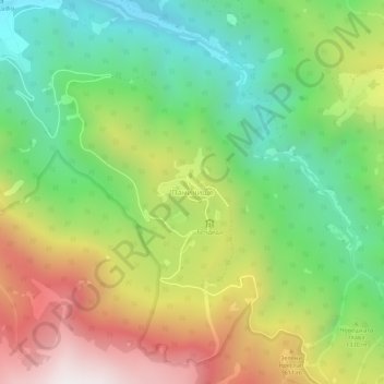
Name: Panichishte topographic map, elevation, terrain.
Location: Panichishte, Sapareva Bania, Kyustendil, 2650, Bulgaria (42.24540 23.27606 42.28540 23.31606)
Average elevation: 4,350 ft
Minimum elevation: 2,543 ft
Maximum elevation: 6,919 ft
Make a donation
Gear up for your next adventure:
As an Amazon Associate, this site earns from qualifying purchases at no extra cost to you.
Other topographic maps
Click on a map to view its topography, its elevation and its terrain.
Kyustendil
Kyustendil is a national balneological resort at an altitude of 600 metres. There are more than 40 mineral springs in the town. The waters have a high content of sulfite compounds. These are used for the treatment of the locomotory system, gynecological and other kinds of diseases. The resort region includes…
Average elevation: 3,081 ft