
Make a donation
Gear up for your next adventure:
As an Amazon Associate, this site earns from qualifying purchases at no extra cost to you.
Chalkoutsi topographic map
Click on the map to display elevation.
Make a donation
Gear up for your next adventure:
As an Amazon Associate, this site earns from qualifying purchases at no extra cost to you.
About this map
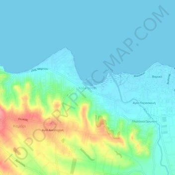
Name: Chalkoutsi topographic map, elevation, terrain.
Average elevation: 69 ft
Minimum elevation: -3 ft
Maximum elevation: 302 ft
Make a donation
Gear up for your next adventure:
As an Amazon Associate, this site earns from qualifying purchases at no extra cost to you.
Other topographic maps
Click on a map to view its topography, its elevation and its terrain.
Municipality of Vari - Voula - Vouliagmeni
Greece > Attica > Regional Unit of East Attica
Average elevation: 161 ft
Make a donation
Gear up for your next adventure:
As an Amazon Associate, this site earns from qualifying purchases at no extra cost to you.
Kalyvia Thorikou Municipal Unit
Greece > Attica > Regional Unit of East Attica
Average elevation: 433 ft
Make a donation
Gear up for your next adventure:
As an Amazon Associate, this site earns from qualifying purchases at no extra cost to you.
Dioni
Greece > Attica > Regional Unit of East Attica > Pikermi Municipal Unit
Average elevation: 791 ft
Municipality of Vari - Voula - Vouliagmeni
Greece > Attica > Regional Unit of East Attica
Average elevation: 161 ft
Make a donation
Gear up for your next adventure:
As an Amazon Associate, this site earns from qualifying purchases at no extra cost to you.
Gerakas Municipal Unit
Greece > Attica > Regional Unit of East Attica > Gerakas Municipal Unit
Average elevation: 850 ft
Make a donation
Gear up for your next adventure:
As an Amazon Associate, this site earns from qualifying purchases at no extra cost to you.