
Make a donation
Gear up for your next adventure:
As an Amazon Associate, this site earns from qualifying purchases at no extra cost to you.
Αρχή topographic map
Click on the map to display elevation.
Make a donation
Gear up for your next adventure:
As an Amazon Associate, this site earns from qualifying purchases at no extra cost to you.
About this map
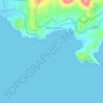
Name: Αρχή topographic map, elevation, terrain.
Location: Αρχή, Regional Unit of East Attica, Attica, Greece (37.65175 24.01303 37.65260 24.01579)
Average elevation: 49 ft
Minimum elevation: 0 ft
Maximum elevation: 479 ft
Make a donation
Gear up for your next adventure:
As an Amazon Associate, this site earns from qualifying purchases at no extra cost to you.
Other topographic maps
Click on a map to view its topography, its elevation and its terrain.
Municipality of Vari - Voula - Vouliagmeni
Greece > Attica > Regional Unit of East Attica
Average elevation: 161 ft
Artemida
Greece > Attica > Regional Unit of East Attica > Artemida Municipal Unit
Average elevation: 125 ft
Make a donation
Gear up for your next adventure:
As an Amazon Associate, this site earns from qualifying purchases at no extra cost to you.
Λαγονήσι
Greece > Attica > Regional Unit of East Attica > Kalyvia Thorikou Municipal Unit
Average elevation: 98 ft
Make a donation
Gear up for your next adventure:
As an Amazon Associate, this site earns from qualifying purchases at no extra cost to you.
Rafina
Greece > Attica > Regional Unit of East Attica > Rafina Municipal Unit
Average elevation: 144 ft
Nea Makri
Greece > Attica > Regional Unit of East Attica > Nea Makri Municipal Unit
Average elevation: 400 ft
Make a donation
Gear up for your next adventure:
As an Amazon Associate, this site earns from qualifying purchases at no extra cost to you.
Kalyvia Thorikou Municipal Unit
Greece > Attica > Regional Unit of East Attica
Average elevation: 433 ft
Cape Sounion
Greece > Attica > Regional Unit of East Attica > Lavreotiki Municipal Unit
Average elevation: 26 ft
Make a donation
Gear up for your next adventure:
As an Amazon Associate, this site earns from qualifying purchases at no extra cost to you.
Saronis
Greece > Attica > Regional Unit of East Attica > Saronida Municipal Unit
Average elevation: 157 ft
Cape Sounio
Greece > Attica > Regional Unit of East Attica > Lavreotiki Municipal Unit > Kato Sounio
Average elevation: 30 ft
Spata
Greece > Attica > Regional Unit of East Attica > Spata-Loutsa Municipal Unit
Average elevation: 377 ft
Make a donation
Gear up for your next adventure:
As an Amazon Associate, this site earns from qualifying purchases at no extra cost to you.
Dioni
Greece > Attica > Regional Unit of East Attica > Pikermi Municipal Unit
Average elevation: 791 ft
Municipality of Vari - Voula - Vouliagmeni
Greece > Attica > Regional Unit of East Attica
Average elevation: 161 ft
Make a donation
Gear up for your next adventure:
As an Amazon Associate, this site earns from qualifying purchases at no extra cost to you.
Saronis
Greece > Attica > Regional Unit of East Attica > Saronida Municipal Unit
Average elevation: 157 ft
Make a donation
Gear up for your next adventure:
As an Amazon Associate, this site earns from qualifying purchases at no extra cost to you.
Gerakas Municipal Unit
Greece > Attica > Regional Unit of East Attica > Gerakas Municipal Unit
Average elevation: 850 ft