Geolocate

Sakoh topographic map

Click on the map to display elevation.

About this map

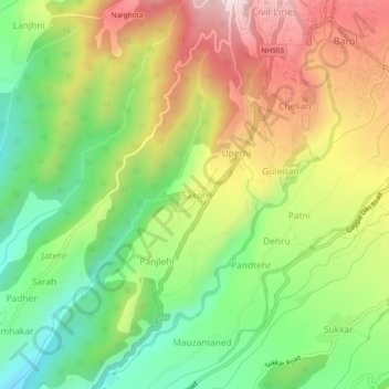
Name: Sakoh topographic map, elevation, terrain.

Location: Sakoh, Dharamshala, Kangra, Himachal Pradesh, 176215, India (32.16751 76.29195 32.20751 76.33195)

Average elevation: 3,353 ft

Minimum elevation: 2,661 ft

Maximum elevation: 4,203 ft

Other topographic maps

Click on a map to view its topography, its elevation and its terrain.

Kareri

India > Himachal Pradesh > Dharamshala

Average elevation: 6,066 ft

Balh

India > Himachal Pradesh > Dharamshala > Dharamshala

Average elevation: 6,253 ft

Gear up for your next adventure:

🧯Portable Fire Pit - Compact fire pit for camping spots
👖Convertible Hiking Pants - Versatile zip-off pants for changing altitudes and temperatures
🔌USB Car Charger - Car charger for on‑the‑go power needs
🛌Ultralight Sleeping Bags - Compact down bags for cold nights in the wilderness
💧Water Filtration Bottles - Safely drink from streams and lakes while exploring

As an Amazon Associate, this site earns from qualifying purchases at no extra cost to you.