Geolocate

Sardinal topographic map

Click on the map to display elevation.

About this map

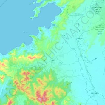
Name: Sardinal topographic map, elevation, terrain.

Location: Sardinal, Carrillo, Guanacaste, 50503, Costa Rica (10.43180 -85.81198 10.63692 -85.57895)

Average elevation: 233 ft

Minimum elevation: 0 ft

Maximum elevation: 1,713 ft

Other topographic maps

Click on a map to view its topography, its elevation and its terrain.

Hermosa

Costa Rica > Carrillo > Sardinal

Average elevation: 148 ft

Gear up for your next adventure:

🧥Waterproof Jacket for Hiking - Breathable and rugged rain jacket for outdoor excursions
🧭GPS Watch Accessories - Bands and chargers for GPS watches
🔪Outdoor Multitools - Essential survival tools for gear repair and field use
🗺️NatGeo Topo Maps - High-quality waterproof printed topographic maps of US Parks
🪓Survival Multi‑Tool - Versatile tool for camp and trail tasks

As an Amazon Associate, this site earns from qualifying purchases at no extra cost to you.