
Make a donation
Gear up for your next adventure:
As an Amazon Associate, this site earns from qualifying purchases at no extra cost to you.
Melsungen topographic map
Click on the map to display elevation.
Make a donation
Gear up for your next adventure:
As an Amazon Associate, this site earns from qualifying purchases at no extra cost to you.
Melsungen
Der tiefste Punkt des Stadtgebiets liegt mit 160 m ü. NN etwas unterhalb des dörflichen Stadtteils Röhrenfurth, an der Mündung der Mülmisch in die Fulda, der höchste mit 557 m ü. NN etwas unterhalb des Himmelsberggipfels (Günsteröder Höhe im Melsunger Bergland). Hier, etwa 2,5 km nordöstlich des dörflichen Stadtteils Günsterode, verläuft die Gemarkungsgrenze zur Nachbarstadt Hessisch Lichtenau.
Make a donation
Gear up for your next adventure:
As an Amazon Associate, this site earns from qualifying purchases at no extra cost to you.
About this map
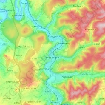
Name: Melsungen topographic map, elevation, terrain.
Location: Melsungen, Schwalm-Eder-Kreis, Hessen, 34212, Deutschland (51.08893 9.50255 51.18485 9.69510)
Average elevation: 1,027 ft
Minimum elevation: 499 ft
Maximum elevation: 1,781 ft
Make a donation
Gear up for your next adventure:
As an Amazon Associate, this site earns from qualifying purchases at no extra cost to you.
Other topographic maps
Click on a map to view its topography, its elevation and its terrain.
Homberg (Efze)
Deutschland > Hessen > Schwalm-Eder-Kreis
Landtage der hessischen Stände fanden auf Grund der guten Erreichbarkeit in den Jahren 1508, 1509, 1514, 1518 und 1536 in Homberg in der Stadtkirche statt. Die von Landgraf Philipp dem Großmütigen einberufene Homberger Synode vom 20. bis 22. Oktober 1526 markiert einen Höhepunkt in der Homberger…
Average elevation: 883 ft
Make a donation
Gear up for your next adventure:
As an Amazon Associate, this site earns from qualifying purchases at no extra cost to you.
Spangenberg
Deutschland > Hessen > Schwalm-Eder-Kreis
Die Stadt Spangenberg hat aktuell (Sommer 2012) Schulden in Höhe von knapp 30 Millionen €. Hinzu kommen Schulden aus Kassenkrediten in Höhe von etwa 15 Millionen €. Dies berechtigt die Stadt Spangenberg zur Teilnahme am Kommunalen Schutzschirm Hessen (KSH). Es steht ein Entschuldungsbetrag in Höhe von…
Average elevation: 1,155 ft
Melsungen
Deutschland > Hessen > Schwalm-Eder-Kreis
Der tiefste Punkt des Stadtgebiets liegt mit 160 m ü. NN etwas unterhalb des dörflichen Stadtteils Röhrenfurth, an der Mündung der Mülmisch in die Fulda, der höchste mit 557 m ü. NN etwas unterhalb des Himmelsberggipfels (Günsteröder Höhe im Melsunger Bergland). Hier, etwa 2,5 km nordöstlich des…
Average elevation: 912 ft
Fritzlar
Deutschland > Hessen > Schwalm-Eder-Kreis
Die etwa 2,7 km lange, 7,5 bis 10 m hohe und an ihrer Basis durchschnittlich 3 m dicke Stadtmauer war an strategischen Stellen mit Türmen versehen und an mindestens fünf Stellen durch Hurden verstärkt, wurde jedoch im Siebenjährigen Krieg auf Befehl französischer Besatzungstruppen auf etwa zwei Drittel…
Average elevation: 702 ft
Make a donation
Gear up for your next adventure:
As an Amazon Associate, this site earns from qualifying purchases at no extra cost to you.
Jesberg
Deutschland > Hessen > Schwalm-Eder-Kreis
Jesberg liegt im Tal des Schwalm-Zuflusses Gilsa am Südostrand des Naturparks Kellerwald-Edersee. Zum Gemeindegebiet gehört der Wüstegarten, der mit 675 m ü. NN höchste Berg des Kellerwalds und des Schwalm-Eder-Kreises. Südwestlich der Gemeinde befindet sich der Höhenzug Hemberg. Durch die Gemeinde…
Average elevation: 935 ft
Körle
Deutschland > Hessen > Schwalm-Eder-Kreis
Körle liegt an der Bahnstrecke Bebra–Baunatal-Guntershausen. Im Dorf befindet sich ein Haltepunkt, an dem die Züge der RegioTram Kassel halten, mit der die Kasseler Innenstadt und der Bahnhof Kassel-Wilhelmshöhe in zirka 20 Minuten erreichbar sind.
Average elevation: 768 ft
Make a donation
Gear up for your next adventure:
As an Amazon Associate, this site earns from qualifying purchases at no extra cost to you.
Gudensberg
Deutschland > Hessen > Schwalm-Eder-Kreis
An einer Wegkreuzung von Gudensberg nach Kassel nördlich von Gudensberg steht das Kasseler Kreuz, ein gotisches Steinkreuz aus dem 14. Jahrhundert. Es handelt sich dabei vermutlich um ein Sühnekreuz eines unbekannten Steinmetzes. Das 1,2 m hohe und 0,6 m breite Kreuz wurde aus unbekanntem Anlass gesetzt.…
Average elevation: 705 ft
Trinkwasserquelle Obergrenzebach
Deutschland > Hessen > Schwalm-Eder-Kreis > Neukirchen
Average elevation: 1,394 ft
Make a donation
Gear up for your next adventure:
As an Amazon Associate, this site earns from qualifying purchases at no extra cost to you.
Felsberg
Deutschland > Hessen > Schwalm-Eder-Kreis
Als Teil der westhessischen Senke liegt sie in einem während des Tertiärs entstandenen Senkungsgebiet. Der Wechsel zwischen teils basaltischen Hügeln und ebenen Flusstälern ist prägend. Während die Täler von fluvialen Sedimenten bedeckt sind, befindet sich in den höhergelegenen Gebieten fruchtbare…
Average elevation: 702 ft
Schnellrode
Deutschland > Hessen > Schwalm-Eder-Kreis
Schnellrode liegt etwa 4,5 km nordnordöstlich des Zentrums der Spangenberger Kernstadt und grenzt nördlich an das Stadtgebiet von Hessisch Lichtenau im Werra-Meißner-Kreis. Nachbarorte sind das nördliche Retterode (zu Hessisch Lichtenau) und die Kernstadt. Es befindet sich südsüdöstlich vom Pentersrück…
Average elevation: 1,293 ft
Make a donation
Gear up for your next adventure:
As an Amazon Associate, this site earns from qualifying purchases at no extra cost to you.
Make a donation
Gear up for your next adventure:
As an Amazon Associate, this site earns from qualifying purchases at no extra cost to you.
Make a donation
Gear up for your next adventure:
As an Amazon Associate, this site earns from qualifying purchases at no extra cost to you.
Wüstung Elberode
Deutschland > Hessen > Schwalm-Eder-Kreis > Obergrenzebach
Average elevation: 1,142 ft
Wüstegarten
Deutschland > Hessen > Schwalm-Eder-Kreis > Densberg
Der Wüstegarten wird von den linken Schwalm-Zuflüssen Urff im Norden und Gilsa im Süden und Osten und vom linken Gilsa-Zufluss Norde im Südwesten begrenzt. Jenseits bzw. südlich der Gilsa schließt sich die Oberhessische Schwelle mit dem Höhenzug Hemberg an.
Average elevation: 1,709 ft
Make a donation
Gear up for your next adventure:
As an Amazon Associate, this site earns from qualifying purchases at no extra cost to you.
Make a donation
Gear up for your next adventure:
As an Amazon Associate, this site earns from qualifying purchases at no extra cost to you.
Make a donation
Gear up for your next adventure:
As an Amazon Associate, this site earns from qualifying purchases at no extra cost to you.
Knüllköpfchen
Deutschland > Hessen > Schwalm-Eder-Kreis > Schwarzenborn
Das Knüllköpfchen liegt im Nordwestteil der Gemarkung der Stadt Schwarzenborn. Seine weitgehend waldfreie Gipfelkuppe zieht sich gut 500 Meter nach Südsüdwesten in die Länge und wird 600 Meter weiter östlich von der mit einem Wäldchen bestandenen Gipfelkuppe des Waldknüll (624,4 m ü. NHN) als…
Average elevation: 1,811 ft
Make a donation
Gear up for your next adventure:
As an Amazon Associate, this site earns from qualifying purchases at no extra cost to you.