
Make a donation
Gear up for your next adventure:
As an Amazon Associate, this site earns from qualifying purchases at no extra cost to you.
Smithtown topographic map
Click on the map to display elevation.
Make a donation
Gear up for your next adventure:
As an Amazon Associate, this site earns from qualifying purchases at no extra cost to you.
About this map
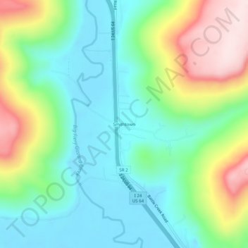
Name: Smithtown topographic map, elevation, terrain.
Location: Smithtown, Marion County, Tennessee, United States (35.06119 -85.75497 35.10119 -85.71497)
Average elevation: 991 ft
Minimum elevation: 597 ft
Maximum elevation: 1,824 ft
Marion County trails, hiking, mountain biking, running and outdoor activities
Make a donation
Gear up for your next adventure:
As an Amazon Associate, this site earns from qualifying purchases at no extra cost to you.
Other topographic maps
Click on a map to view its topography, its elevation and its terrain.
South Pittsburg
United States > Tennessee > Marion County
South Pittsburg is located at 35°0′30″N 85°42′38″W / 35.00833°N 85.71056°W / 35.00833; -85.71056 (35.008342, -85.710645). The city is situated in the southwestern Sequatchie Valley between the Cumberland Plateau on the west and the Tennessee River (Guntersville Lake) on the east. Two steep…
Average elevation: 892 ft
Raccoon Mountain Pumped Station Dam
United States > Tennessee > Marion County > Chattanooga
Average elevation: 1,362 ft
Make a donation
Gear up for your next adventure:
As an Amazon Associate, this site earns from qualifying purchases at no extra cost to you.