
Make a donation
Gear up for your next adventure:
As an Amazon Associate, this site earns from qualifying purchases at no extra cost to you.
Floreffe topographic map
Click on the map to display elevation.
Make a donation
Gear up for your next adventure:
As an Amazon Associate, this site earns from qualifying purchases at no extra cost to you.
Floreffe
Floreffe is een plaats en gemeente in de provincie Namen in België. De gemeente telt ruim 8.000 inwoners en ligt op een hoogte van 160 meter.
Make a donation
Gear up for your next adventure:
As an Amazon Associate, this site earns from qualifying purchases at no extra cost to you.
About this map
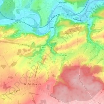
Name: Floreffe topographic map, elevation, terrain.
Location: Floreffe, Namen, Wallonië, België (50.39288 4.73166 50.45093 4.82961)
Average elevation: 568 ft
Minimum elevation: 262 ft
Maximum elevation: 866 ft
Make a donation
Gear up for your next adventure:
As an Amazon Associate, this site earns from qualifying purchases at no extra cost to you.
Other topographic maps
Click on a map to view its topography, its elevation and its terrain.
Make a donation
Gear up for your next adventure:
As an Amazon Associate, this site earns from qualifying purchases at no extra cost to you.