
Cheverly topographic map
Click on the map to display elevation.
About this map
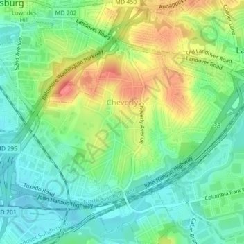
Name: Cheverly topographic map, elevation, terrain.
Location: Cheverly, Prince George's County, Maryland, United States (38.91233 -76.92849 38.93939 -76.89940)
Average elevation: 95 ft
Minimum elevation: 13 ft
Maximum elevation: 233 ft
Other topographic maps
Click on a map to view its topography, its elevation and its terrain.
Sellman Estates
United States > Maryland > Prince George's County > Beltsville
Average elevation: 200 ft
Mount Rainier Neighborhood Park
United States > Maryland > Prince George's County > Mount Rainier
Average elevation: 69 ft
Farmington Road Estates
United States > Maryland > Prince George's County > Farmington Road Estates
Average elevation: 154 ft