Cheyenne topographic map
Click on the map to display elevation.
Cheyenne
Cheyenne lies on the semi-arid High Plains of southeastern Wyoming, at about 6,100 ft (1,860 m) above sea level, where broad prairie surfaces begin to rise toward the Laramie Mountains and the Rocky Mountain foothills to the west. Its topography is generally open, elevated, and gently rolling rather than rugged, with shallow stream corridors such as Crow Creek subtly shaping the urban landscape and surrounding rangeland. The result is a spacious high-plains setting of modest local relief, wide horizons, and gradual elevation transitions, giving Cheyenne the physical character of a windswept plateau city set between expansive grassland and the first stronger uplifts of southeastern Wyoming.
About this map
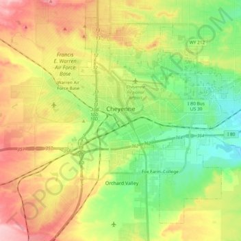
Name: Cheyenne topographic map, elevation, terrain.
Location: Cheyenne, Laramie County, Wyoming, United States (41.07310 -104.86112 41.19303 -104.67493)
Average elevation: 6,138 ft
Minimum elevation: 5,915 ft
Maximum elevation: 6,437 ft
Laramie County trails, hiking, mountain biking, running and outdoor activities
Other topographic maps
Click on a map to view its topography, its elevation and its terrain.