Geolocate

St. Thomas topographic map

Click on the map to display elevation.

About this map

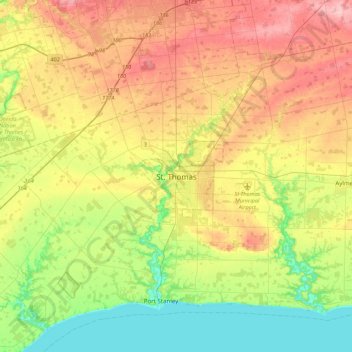
Name: St. Thomas topographic map, elevation, terrain.

Location: St. Thomas, Southwestern Ontario, Ontario, N5P 2X5, Canada (42.61902 -81.35299 42.93902 -81.03299)

Average elevation: 758 ft

Minimum elevation: 558 ft

Maximum elevation: 1,017 ft

Other topographic maps

Click on a map to view its topography, its elevation and its terrain.

St. Thomas Elevated Park

Canada > Ontario > St. Thomas

Average elevation: 738 ft

Gear up for your next adventure:

🌎3D Topographic Globes - Raised relief globes for a tactile understanding of geography
🎒Gear Packing Cubes - Organize your backpack efficiently
🌐World Map Poster - Decorative world maps with topographic info
🧼Biodegradable Camping Soap - Eco‑friendly soap for outdoor hygiene
🧥Waterproof Jacket for Hiking - Breathable and rugged rain jacket for outdoor excursions

As an Amazon Associate, this site earns from qualifying purchases at no extra cost to you.