
Denny Mountain topographic map
Interactive map
Click on the map to display elevation.
About this map
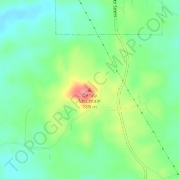
Name: Denny Mountain topographic map, elevation, terrain.
Location: Denny Mountain, Nacogdoches County, Texas, 75760, USA (31.79512 -94.84388 31.79522 -94.84378)
Average elevation: 449 ft
Minimum elevation: 358 ft
Maximum elevation: 623 ft
Other topographic maps
Click on a map to view its topography, its elevation and its terrain.
Silver Valley
USA > Texas > Silver Valley
Silver Valley, Coleman County, Texas, USA
Average elevation: 1,998 ft
Twin Mountains
USA > Texas > Twin Mountains
Twin Mountains, Young County, Texas, 76450, USA
Average elevation: 1,079 ft
PROFESSIONAL COMMUNICATIONS
PROFESSIONAL COMMUNICATIONS, West 25th Street, Cottage, West Odessa, Ector County, Texas, 79763, USA
Average elevation: 2,943 ft
Nelson City
USA > Texas > Nelson City
Nelson City, Kendall County, Texas, USA
Average elevation: 1,591 ft
Karnes City
USA > Texas > Karnes City
Karnes City, Karnes County, Texas, 78118, USA
Average elevation: 400 ft
Ingleside on the Bay
USA > Texas > Ingleside on the Bay
Ingleside on the Bay, San Patricio County, Texas, USA
Average elevation: 13 ft
Post Oak Ridge
USA > Texas > Lago Vista
Post Oak Ridge, Lago Vista, Travis County, Texas, 78645, USA
Average elevation: 1,030 ft
Guadalupe Peak
Guadalupe Peak, Culberson County, Texas, 79847, USA
Average elevation: 7,057 ft