
Make a donation
Gear up for your next adventure:
As an Amazon Associate, this site earns from qualifying purchases at no extra cost to you.
Motta topographic map
Click on the map to display elevation.
Make a donation
Gear up for your next adventure:
As an Amazon Associate, this site earns from qualifying purchases at no extra cost to you.
About this map
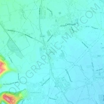
Name: Motta topographic map, elevation, terrain.
Location: Motta, Costabissara, Vicenza, Veneto, 36030, Italy (45.58109 11.47731 45.62109 11.51731)
Average elevation: 171 ft
Minimum elevation: 125 ft
Maximum elevation: 505 ft
Make a donation
Gear up for your next adventure:
As an Amazon Associate, this site earns from qualifying purchases at no extra cost to you.
Other topographic maps
Click on a map to view its topography, its elevation and its terrain.
Bassano del Grappa
Rubbio is a frazione and quartiere located at an altitude of 1,057 m (3,468 ft) on the Asiago plateau. This hamlet is contiguous with another hamlet, also named Rubbio, which is part of the commune of Lusiana Conco. Thus, in practice, the two hamlets form one village (named Rubbio), even though they belong to…
Average elevation: 738 ft
Bassano del Grappa
Rubbio is a frazione and quartiere located at an altitude of 1,057 m (3,468 ft) on the Asiago plateau. This hamlet is contiguous with another hamlet, also named Rubbio, which is part of the commune of Conco. Thus, in practice, the two hamlets form one village (named Rubbio), even though they belong to two…
Average elevation: 738 ft
Make a donation
Gear up for your next adventure:
As an Amazon Associate, this site earns from qualifying purchases at no extra cost to you.
Salcedo
The town of Salcedo has an approximate population of 1,021 people were 514 are males and 507 are females. The approximate number of families is around 394 with a total of around 495 housing units. The population is most commonly known as the Salcedensi and their Patron Saint is Sant'Anna. The zip code is 36040…
Average elevation: 1,125 ft
Make a donation
Gear up for your next adventure:
As an Amazon Associate, this site earns from qualifying purchases at no extra cost to you.
Posina
Posina is a town in the province of Vicenza, Veneto, Italy. It is northeast of SS46. As of 2007 Posina had an estimated population of 657. Posina lies at an elevation of 600 metres (2,000 ft) at the foot of Mount Majo and Mount Gamonda, Mount Pasubio. On the whole dominates the Pasubio which can be accessed…
Average elevation: 3,268 ft
Make a donation
Gear up for your next adventure:
As an Amazon Associate, this site earns from qualifying purchases at no extra cost to you.
Make a donation
Gear up for your next adventure:
As an Amazon Associate, this site earns from qualifying purchases at no extra cost to you.