
Make a donation
Gear up for your next adventure:
As an Amazon Associate, this site earns from qualifying purchases at no extra cost to you.
La Roche topographic map
Click on the map to display elevation.
Make a donation
Gear up for your next adventure:
As an Amazon Associate, this site earns from qualifying purchases at no extra cost to you.
About this map
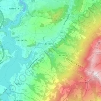
Name: La Roche topographic map, elevation, terrain.
Location: La Roche, District de la Gruyère, Fribourg, 1634, Suisse (46.66838 7.11743 46.71581 7.21671)
Average elevation: 3,159 ft
Minimum elevation: 2,001 ft
Maximum elevation: 5,604 ft
Make a donation
Gear up for your next adventure:
As an Amazon Associate, this site earns from qualifying purchases at no extra cost to you.
Other topographic maps
Click on a map to view its topography, its elevation and its terrain.
La Sarine
Suisse > Fribourg > District de la Gruyère > Bas-Intyamon > Villars-sous-Mont
Average elevation: 2,943 ft
La Tour-de-Trême
Suisse > Fribourg > District de la Gruyère > Bulle > La Tour-de-Trême
Average elevation: 2,487 ft