
Watchung topographic map
Click on the map to display elevation.
About this map
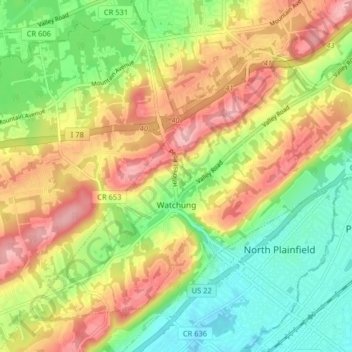
Name: Watchung topographic map, elevation, terrain.
Location: Watchung, Somerset County, New Jersey, 07069, United States (40.61777 -74.48243 40.66801 -74.40184)
Average elevation: 302 ft
Minimum elevation: 66 ft
Maximum elevation: 577 ft
Somerset County trails, hiking, mountain biking, running and outdoor activities
Other topographic maps
Click on a map to view its topography, its elevation and its terrain.
Basking Ridge
United States > New Jersey > Somerset County > Bernards Township
Average elevation: 322 ft
Neshanic
United States > New Jersey > Somerset County > Hillsborough Township
Average elevation: 213 ft
Woods Tavern
United States > New Jersey > Somerset County > Hillsborough Township
Average elevation: 92 ft
Bloomingdale
United States > New Jersey > Somerset County > Hillsborough Township
Average elevation: 95 ft
Basking Ridge
United States > New Jersey > Somerset County > Bernards Township
Average elevation: 322 ft
Blaziers Corner
United States > New Jersey > Somerset County > Bernardsville
Average elevation: 404 ft
Chimney Rock
United States > New Jersey > Somerset County > Bridgewater Township
Average elevation: 184 ft
Neshanic
United States > New Jersey > Somerset County > Hillsborough Township
Average elevation: 213 ft
Rock Mill
United States > New Jersey > Somerset County > Montgomery Township
Average elevation: 410 ft
North Branch Depot
United States > New Jersey > Somerset County > North Branch Depot
Average elevation: 125 ft
Liberty Corner
United States > New Jersey > Somerset County > Bernards Township > Liberty Corner
Average elevation: 279 ft
Green Knoll
United States > New Jersey > Somerset County > Bridgewater Township
Average elevation: 207 ft