
Make a donation
Gear up for your next adventure:
As an Amazon Associate, this site earns from qualifying purchases at no extra cost to you.
São José do Rio Pardo topographic map
Click on the map to display elevation.
Make a donation
Gear up for your next adventure:
As an Amazon Associate, this site earns from qualifying purchases at no extra cost to you.
São José do Rio Pardo
São José do Rio Pardo is a municipality in the state of São Paulo in Brazil. The population is 55,124 (2020 est.) in an area of 419 km2. The elevation is 676 m. It was founded by Colonel Antônio Marçal Nogueira de Barros in 1870. In the same year, a chapel to Saint Joseph was built. It became a municipality in 1885, when it was separated from Casa Branca. In the late 1800s and the early 1900s the town received a mass of immigration from northern Italy, those immigrants went to town for working in the coffee fields in replacement of the slave workforce, since slaves were set free in 1888 by an act of Princess Elizabeth.
Make a donation
Gear up for your next adventure:
As an Amazon Associate, this site earns from qualifying purchases at no extra cost to you.
About this map
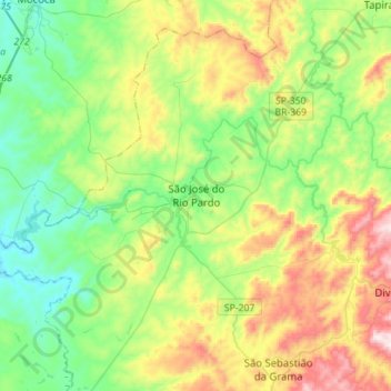
Name: São José do Rio Pardo topographic map, elevation, terrain.
Average elevation: 2,612 ft
Minimum elevation: 1,824 ft
Maximum elevation: 4,226 ft
Make a donation
Gear up for your next adventure:
As an Amazon Associate, this site earns from qualifying purchases at no extra cost to you.
Other topographic maps
Click on a map to view its topography, its elevation and its terrain.
São Paulo
Brazil > São Paulo > Região Metropolitana de São Paulo
The city is on a plateau placed beyond the Serra do Mar (Portuguese for "Sea Range" or "Coastal Range"), itself a component of the vast region known as the Brazilian Highlands, with an average elevation of around 799 meters (2,621 ft) above sea level, although being at a distance of only about 70 kilometers…
Average elevation: 2,575 ft
Rio Perdido
Brazil > São Paulo > Região Metropolitana da Baixada Santista > Santos
Average elevation: 203 ft
Araçariguama
Brazil > São Paulo > Região Metropolitana de Sorocaba > Araçariguama > Araçariguama
Araçariguama is a city on the state of São Paulo in Brazil. It is part of the Metropolitan Region of Sorocaba. The population of city is of 22,860 (2020 est.) in an area of 145.20 km². The elevation is 695 m. Araçariguama was established in 1653.
Average elevation: 2,428 ft
Make a donation
Gear up for your next adventure:
As an Amazon Associate, this site earns from qualifying purchases at no extra cost to you.
Jundiaí
Jundiaí is a municipality in the state of São Paulo, in the Southeast Region of Brazil, located 57 kilometres (35 mi) north of São Paulo. The population of the city is 423,006 (2020 est.), with an area of 431.21 km². The elevation is 761 m. The GDP of the city is U$16.6 billion (R$36.6 billion). The budget…
Average elevation: 2,651 ft
Sorocaba
Brazil > São Paulo > Região Metropolitana de Sorocaba > Sorocaba
The terrain is classified as a wavy strands and characterized by local ridges, with an average altitude of 632 meters above the sea level. The highest altitude is 1028 meters, in the Serra de Sao Francisco. The lower altitude is 539 meters, in the valley of the Sorocaba River. Sorocaba is located on the edge…
Average elevation: 2,172 ft
São Francisco Xavier
Brazil > São Paulo > Região Metropolitana do Vale do Paraíba e Litoral Norte > São José dos Campos
Average elevation: 2,795 ft
Make a donation
Gear up for your next adventure:
As an Amazon Associate, this site earns from qualifying purchases at no extra cost to you.
São José dos Campos
Brazil > São Paulo > Região Metropolitana do Vale do Paraíba e Litoral Norte > São José dos Campos
In the urban area, there are rolling plateaus and hills. The lowest elevation in the city (and also in the municipality) is found in the Paraíba do Sul River, at a mean elevation of 550 m.
Average elevation: 2,080 ft
São Bernardo do Campo
Brazil > São Paulo > Região Metropolitana de São Paulo > São Bernardo do Campo
Average elevation: 2,493 ft