
Houghs Neck topographic map
Interactive map
Click on the map to display elevation.
About this map
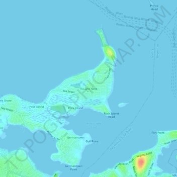
Name: Houghs Neck topographic map, elevation, terrain.
Average elevation: 7 ft
Minimum elevation: -7 ft
Maximum elevation: 144 ft
Other topographic maps
Click on a map to view its topography, its elevation and its terrain.
Germantown
United States > Massachusetts > Norfolk County > Quincy
Germantown, Quincy, Norfolk County, Massachusetts, 02191, United States
Average elevation: 16 ft
South Quincy
United States > Massachusetts > Norfolk County > Quincy
South Quincy, Quincy, Norfolk County, Massachusetts, 02269, United States
Average elevation: 82 ft
Rock Island
United States > Massachusetts > Norfolk County > Quincy
Rock Island, Quincy, Norfolk County, Massachusetts, 02191, United States
Average elevation: 10 ft
Quincy Point
United States > Massachusetts > Norfolk County > Quincy
Quincy Point, Quincy, Norfolk County, Massachusetts, 02169, United States
Average elevation: 39 ft
Blue Hills Reservation
United States > Massachusetts > Norfolk County > Quincy
Blue Hills Reservation, Quincy, Norfolk County, Massachusetts, United States
Average elevation: 157 ft
Quincy
United States > Massachusetts > Norfolk County > Quincy
Quincy, Norfolk County, Massachusetts, 02169, United States
Average elevation: 92 ft
Atlantic
United States > Massachusetts > Norfolk County > Quincy > Atlantic
Atlantic, Quincy, Norfolk County, Massachusetts, 02171, United States
Average elevation: 23 ft
North Commons
United States > Massachusetts > Norfolk County > Quincy
North Commons, Quincy, Norfolk County, Massachusetts, 02269, United States
Average elevation: 85 ft
Seal Rock
United States > Massachusetts > Norfolk County > Quincy
Seal Rock, Quincy, Norfolk County, Massachusetts, 02191, United States
Average elevation: 92 ft