
Make a donation
Gear up for your next adventure:
As an Amazon Associate, this site earns from qualifying purchases at no extra cost to you.
Bromont topographic map
Click on the map to display elevation.
Make a donation
Gear up for your next adventure:
As an Amazon Associate, this site earns from qualifying purchases at no extra cost to you.
About this map
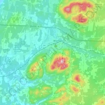
Name: Bromont topographic map, elevation, terrain.
Location: Bromont, Brome-Missisquoi, Estrie, Quebec, Canada (45.25158 -72.79941 45.35205 -72.58758)
Average elevation: 630 ft
Minimum elevation: 315 ft
Maximum elevation: 1,811 ft
Make a donation
Gear up for your next adventure:
As an Amazon Associate, this site earns from qualifying purchases at no extra cost to you.
Other topographic maps
Click on a map to view its topography, its elevation and its terrain.
Paradis-des-Chênes
Canada > Quebec > Brome-Missisquoi > Dunham > Paradis-des-Chênes
Average elevation: 548 ft
Make a donation
Gear up for your next adventure:
As an Amazon Associate, this site earns from qualifying purchases at no extra cost to you.